Symbolic, spiritual, healing
Vision: A living, cultural landscape cared for by Traditional Owners and the community to protect its values, heal and build resilience
Traditional Owners of the Greater Gariwerd are represented by Barengi Gadjin Land Council, Gunditj Mirring Traditional Owners Aboriginal Corporation and Eastern Maar Aboriginal Corporation. Together, they form a Strategic Partnership Committee of Traditional Owners.
Greater Garwierd has been home to the Djab Wurrung and Jadawadjali language groups and ancestors for more than 22,000 years and contains the densest concentration of rock art and the largest assemblage of Aboriginal art motifs in Victoria.
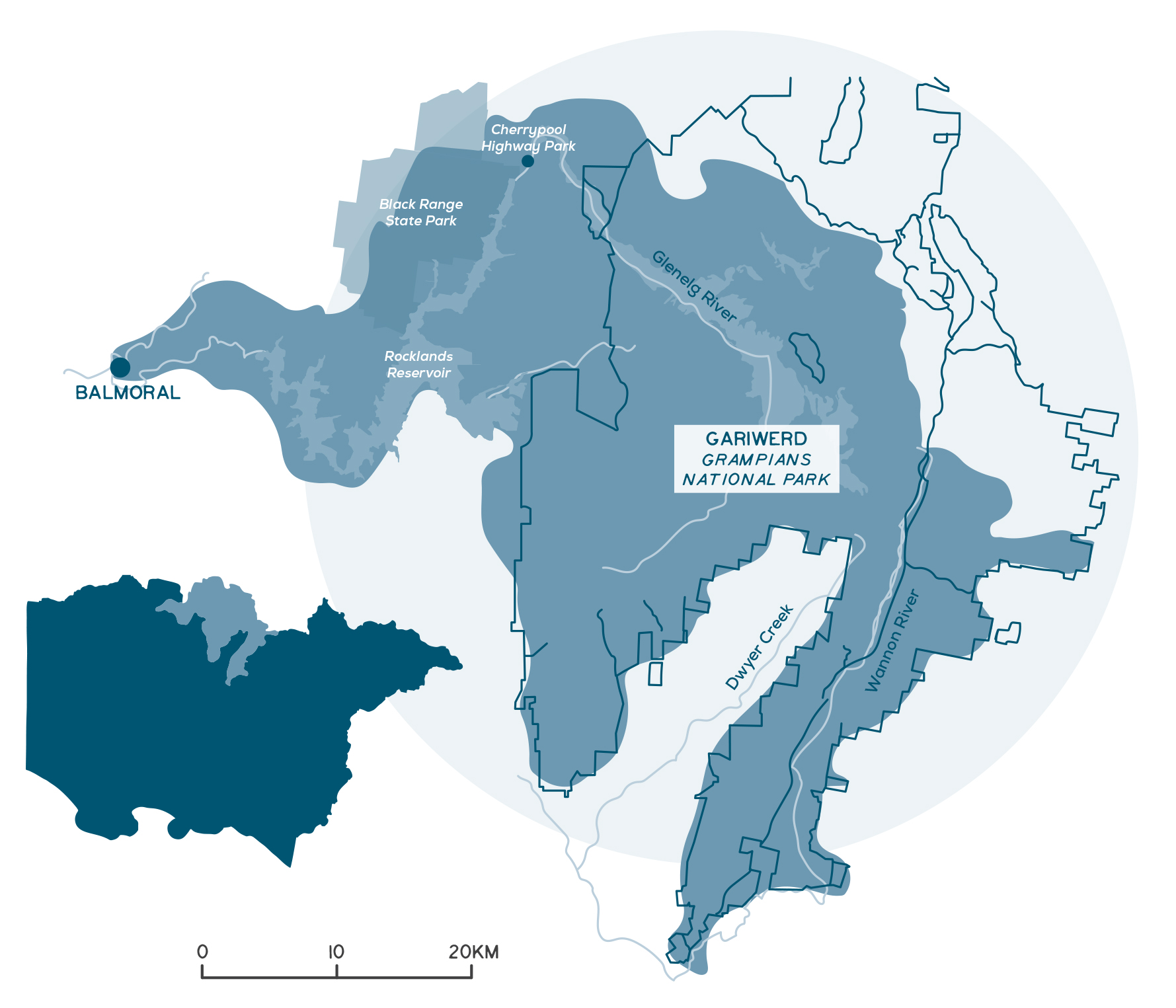
This local area aligns with the southern portion of the Greater Gariwerd (Grampians) Landscape – including Gariwerd (Grampians), Black Range State Park, Cherrypool Highway Park, Brady Swamp State Game Reserve and Rocklands Reservoir.
Gariwerd is the generic name for a pointed mountain or mountain range. More specifically, in Jadawadjali language, ‘gar’ means ‘pointed mountain’; ‘i’ means ‘the’ and ‘werd’ means ‘shoulder’.
In addition to rock art across the broader Gariwerd landscape, Aboriginal places include burials, mounds, stone arrangements, freshwater middens, rock quarries, artefact scatters, archaeological layers and scar trees, and larger areas that also include intangible values such as creation stories.
Local Government Authorities include Ararat Rural City, Horsham Rural City Council, Northern Grampians Shire Council and Southern Grampians Shire.
A snapshot of Southern Gariwerd & the Black Range
- A highly significant landscape for Traditional Owners.
- Densest concentration of rock art and Aboriginal art motifs in Australia.
- Native vegetation covers 88% of the area.
- Gariwerd contains more than 1,000 plant species, including 23 species that are found nowhere else in the world.
- There is a small amount of agricultural production on the periphery, including grazing and hardwood plantations.
- More than 1.3 million people per year visit the area.
- Contains the headwaters of the Glenelg River, Wannon River and Dwyers Creek.
- Rocklands Reservoir is a popular location for outdoor activities including fishing and camping.
- Key threats include loss of biodiversity, climate change and bushfires. Water harvesting affects the volume, duration and flow for both Glenelg and Wannon Rivers. Recreational and commercial use impacts on the areas natural and cultural values.
Detailed overview
Greater Gariwerd is a highly significant living, cultural landscape for Traditional Owners – reflecting their voice, knowledge, history, heritage, and cultural practices. Within the Glenelg Hopkins region, the following parks and reserves form part of Greater Gariwerd Landscape:
- Gariwerd (Grampians National Park), created in 1984.
- Black Range State Park, created in 1988.
- Cherrypool Highway Park, created in 1983.
- Brady Swamp State Game Reserve, created in 1993.
Gariwerd was listed on the National Heritage Register in December 2006 for its outstanding cultural heritage, landscape, and biodiversity values. Major Thomas Mitchell named the mountains the ‘Grampians’ after scaling Mt Duwil (Mt William), the highest peak, with a small group of explorers in 1836. The arrival of European settlers soon after irrevocably changed the lives of the region’s Traditional Owners. Western Victoria has a particularly rapid and brutal history of dispossession and massacres.
By the mid-1840s the Grampians had become a centre for farming, mining and timber production, and a source of water for surrounding farmland. Water extraction, land clearing and the introduction of grazing forever changed the landscape and ecosystems Traditional Owners had relied upon.
Gariwerd was designated as state forest in 1872 and declared a national park in 1984. As most of the western Victoria plains had been cleared for agriculture, the remnant bushland in the park has become a refuge for native plants and animals. The Park contains more than 1,000 plant species, including 23 species that are found nowhere else in the world.
The Southern Gariwerd and Black Range local area provides habitat for a large number of rare and threatened species, including 33 recorded fauna species such as the western swamp cray (critically endangered), growling grass frog (endangered) and heath mouse (endangered), and 42 flora species, including the endemic Grampians pincushion-lily (endangered), metallic sun-orchid (endangered) and trailing hop-bush (vulnerable).
There is some agricultural production on the periphery of the national park, including grazing and hardwood plantations.
More than 1.3 million people per year visit Gariwerd – international, national, state, local, school groups, retirees, tree changers and outdoor enthusiasts. Many of these visitors continue to other locations and contribute to the tourism economy of the Glenelg Hopkins region.
Rocklands reservoir
This local area includes the Glenelg Hopkins portion of the Greater Grampians bioregion and areas of the Dundas Tablelands bioregion around Rocklands and Cherrypool. This includes the most intact areas of native vegetation in the Glenelg Hopkins region. The distinctive form of the Grampians is the result of folding, faulting and subsequent erosion of sandstone. Dwarfed eucalypt woodlands and heathlands can be found along the highest peaks and ridges, often dominated by endemics such as the Mt Abrupt stringybark and the Grampians grey-gum, while taller wet eucalypt forests are found on the eastern slopes of the Victoria and Serra Ranges. Red gum woodland and wet heathland commonly surround what were once swamps but are now man-made water storages.
The headwaters of the Glenelg River, Wannon River and Dwyers Creek are found within this local area, with the Wannon being one of the five listed ecologically healthy river reaches in the region. Almost three-quarters of Gariwerd is used as special water supply catchment areas, producing high-quality water to supply western Victoria, which is important to the regional economy. The significance of water to the ecosystems and economy of the region is one of the reasons the National Park was created.
There are relatively few wetlands across this local area due to its topography. Where they do occur, they are generally temporary freshwater marshes and swamps formed on the flats. Brady Swamp, for example, is adjacent to the far south-eastern corner of the Gariwerd (Grampians National Park), straddling public (Brady Swamp Wildlife Reserve) and private land. The swamp is one in a chain of wetlands of the Wannon River Floodplain, as the river reaches the flats after exiting the valley between the Serra and Mt William Ranges within the Grampians.
Other key areas in this landscape include:
- Black Range State Park, which is less frequented than Gariwerd, is notable for its rugged stone escarpments and range of interesting and uncommon plant species and important fauna species.
- The Rocklands and Grampians State Forest, which includes the Rocklands Reservoir, Grampians State Forest and Claude Austin State Forest is popular for a wide range of outdoor activities including camping, fishing, bush walking and nature study. Rocklands Reservoir was constructed during the 1950s along the Glenelg River to supply the now decommissioned Wimmera-Mallee domestic and stock channel system. Water for the environment is released from Rocklands Reservoir, under strict conditions, to provide additional flow to the Glenelg River.
Challenges and threats
The management of Greater Gariwerd needs to address the threats to the natural, cultural, and social values of the landscape, whilst supporting recreational experiences.
Gariwerd is rich in cultural values and heritage, and should be celebrated through cultural renewal and strengthening of connection to Country, where traditional knowledge, language and practices are incorporated.
The cultural history of Gariwerd, particularly of conflict and massacres, has rarely been told or acknowledged. There is an opportunity to recognise that Aboriginal people were dispossessed and unable to assert their native title rights and interests.
The continuing loss of biodiversity and climate change impacts could mean protecting the Gariwerd landscape’s unique natural values will become even more challenging, but vitally important.
Climate change is emerging as the most concerning threat. Since 2006, climate change has been linked to three major bushfires that have collectively burnt 90% of Gariwerd. These were three of the largest fires ever recorded in the region and have resulted in dramatic declines in small mammal populations. There is little, long-unburnt vegetation in the park that these small mammal populations require to thrive. Introduced predators have a significant effect on native animals across the area.
The most extensive areas of native vegetation in the Glenelg Hopkins region are found in this local area, with native vegetation covering 88% of the area. Since 1990, native vegetation has declined by 1%. There has been a 30% decline in native grassland and a 6% decline in heathlands across the park and increases in woodland and forest cover (3% increase), scattered trees (6% increase) and native vegetation cover in seasonal wetlands (19% increase).
Weed invasion is relatively low compared to other Glenelg Hopkins local areas. However, the native shrub manuka has been increasing in density in the red gum woodlands of the Victoria Valley for several decades, possibly in response to a decline in fire frequency and the legacy of historical grazing. This is leading to declines in native understory diversity.
Grampians triggerplant
The health of the waterways and associated ecosystems within the park are important to maintain and improve, as water has an impact far beyond the physical boundaries of the National Park. For example, water from the Glenelg River is diverted into the Wimmera Mallee pipeline reaching as far as Wyperfield National Park, 150 km north-west. Water is also harvested from the upper catchment of the Wannon River to supply Lake Bellfied in the Wimmera system. Threats to water quality and availability in this local area include the health of upstream catchments, impacts of climate change due to more variable rainfall and temperature patterns and bushfires. The management of water is closely affected by decision making.
Water has been harvested within Gariwerd since Europeans settled the area in the late 1800s. While little is known about the impact of early water harvesting on park ecosystems, construction of the Moora Moora Reservoir, artificial lakes, drainage channels and clearing of some areas for tracks have significantly reduced stream flow in some areas, impacting the wetland habitat available as well as vegetation communities that rely on regular inundation (such as river red gums). In addition, the operation of Rocklands Reservoir has also significantly reduced the volume, duration, and magnitude of flows in the Glenelg River and caused significant stress to ecological values. High salinity, low dissolved oxygen and reduced sediment flushing are directly attributable to altered flow regimes.
Recreational and commercial activities also have a significant impact on park values. For example, increased climbing and walking can fragment significant plant communities, disperse pathogens, spread weeds, contribute to soil compaction, disturb wildlife, affect water quality (through poor toileting and rubbish disposal), increase the risk of bushfires and damage cultural artefacts and heritage sites. With tourism numbers continuing to increase, minimising the impacts of recreational and commercial activities will be an ongoing challenge.
There are opportunities for interpretation and educational experiences that deepen visitor knowledge of the landscapes environmental and cultural values. Opportunities also exist by working in partnership with other agencies, and surrounding landholders to consider whole of landscape connectivity and management impacts and actions that reach beyond the boundaries of Greater Gariwerd.
Photo: Southern Grampians Shire
Photo: Southern Grampians Shire
Photo: Southern Grampians Shire
Community priorities and interests
The outcomes and priority management directions for the strategy are detailed under each theme, these set the strategic framework for the strategy.
Although all outcomes in the RCS are a priority across the region, each local area has different priorities for implementation based on the local values, threats, and community priorities. The strategy will be implemented via specific projects, or the core activities of a range of agencies, groups and local people involved in managing and conserving natural resources and biodiversity values.
Community priorities and interests that relate to the Southern Gariwerd and Black Range local area are outlined below. These priorities and interests have been raised by community and partners through the RCS engagement process. These are also reflected in the priority management directions under each theme and together they guide the implementation of the RCS within the different local areas.
Traditional Owner groups
Further detail on Traditional Owner groups in this local area can be found on their individual pages – click the names below:
* Barengi Gadjin Land Council
* Eastern Maar Aboriginal Corporation
* Gunditj Mirring Traditional Owners Aboriginal Corporation
