The Glenelg Hopkins region is a diverse landscape, covering volcanic plains, grassy woodlands and eucalypt forests, productive Sea Country, significant rivers and extensive wetland systems. These landscapes are rich in plant and animal life that have sustained permanent settlements of Aboriginal people across the region. Physical evidence and oral traditions describing volcanic activity indicate these lands have supported human populations for at least 27,000 years1,2. Thousands of ancient and more recent Aboriginal heritage places can be found throughout the region, including scarred trees, stone arrangements, middens, rock paintings, stone house sites, mission sites, fish traps and quarries.
Aboriginal peoples and communities have retained a strong identity and connection to the traditional lands for which they have custodial rights and responsibilities. Today, the Glenelg Hopkins catchment area coincides with four Traditional Owner groups that manage the region’s unique cultural and natural values through critical initiatives such as Indigenous Protected Areas, joint-managed National Parks and private land holdings.
In 2019, the United Nations Educational, Scientific and Cultural Organisation (UNESCO) bestowed Word Heritage Status on the Budj Bim Cultural Landscape – the first World Heritage listing of any Australian Indigenous place to be registered explicitly for its cultural values. The region also contains the National Heritage listed Gariwerd (Grampians National Park). Gariwerd is one of the best known parks in Victoria, and is recognised for its outstanding natural and cultural values.
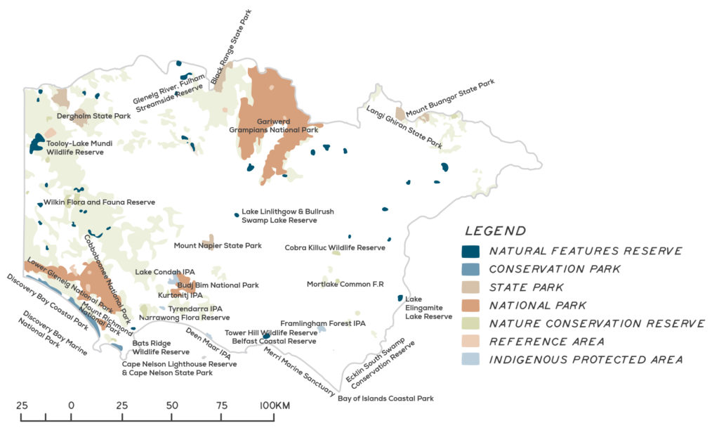
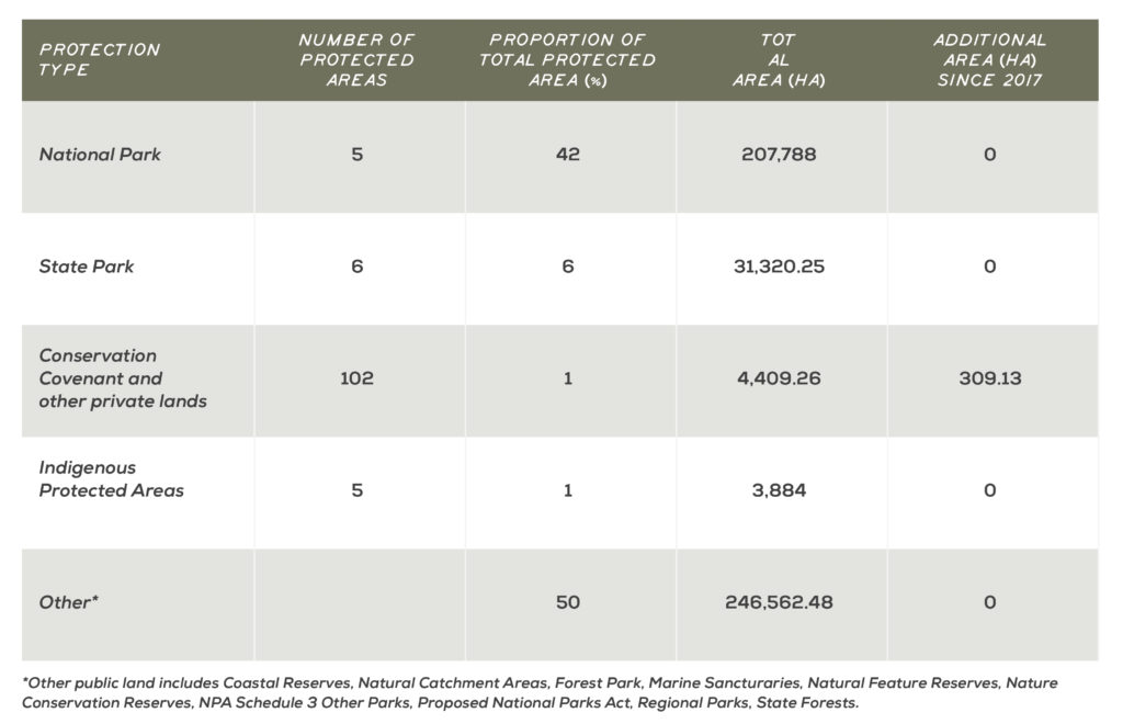
Public land accounts for 18% of the Glenelg Hopkins land area. This includes four National Parks – Lower Glenelg (27,300 ha), Mount Richmond (4,280 ha), Cobboboonee (18,510 ha), Gariwerd (Grampians) (167,219 ha) and Budj Bim (5,470 ha) – as well as State Parks and other public land reserves. An important feature is the region’s five Indigenous Protected Areas (IPAs). Managed for biodiversity and Aboriginal cultural values, IPAs cover almost 4,000 ha and include the coastal island of Deen Maar, Tyrendarra, Framlingham Forest, Kurtonitj and Lake Condah. Private land conservation covenants, totalling around 4,400 ha, provide valuable habitat for species in areas that are poorly represented by public reserves, as well as enhancing habitat connectivity between reserves.
Since European settlement, the region has undergone extensive land clearing for agriculture and urban development. Around 83% of the original native vegetation has been cleared, and 81% of land is now farmed. Agricultural land use varies considerably across the catchment and is influenced by a range of factors including: land capability (e.g. soil type, terrain), commodity prices and access to supporting infrastructure. Major agricultural land use classes include cropping, dairy, sheep and beef production. Most regional farms are mixed operations, producing more than one agricultural commodity. Cropping, often in conjunction with sheep or cattle, is dominant in the north-east of the catchment, while dairying is dominant around Warrnambool, and in the region’s south-east. Softwood (mostly Pinus radiata) and hardwood forestry plantations are a common feature of the landscape, particularly in the western and south-west parts of the catchment.
Sheep grazing is the region’s largest land use
Photo: Summit Park Enterprises
A mozaic of land used for agriculture and conservation
Photo: Hopkins River Beef
Assessment of current condition and trends
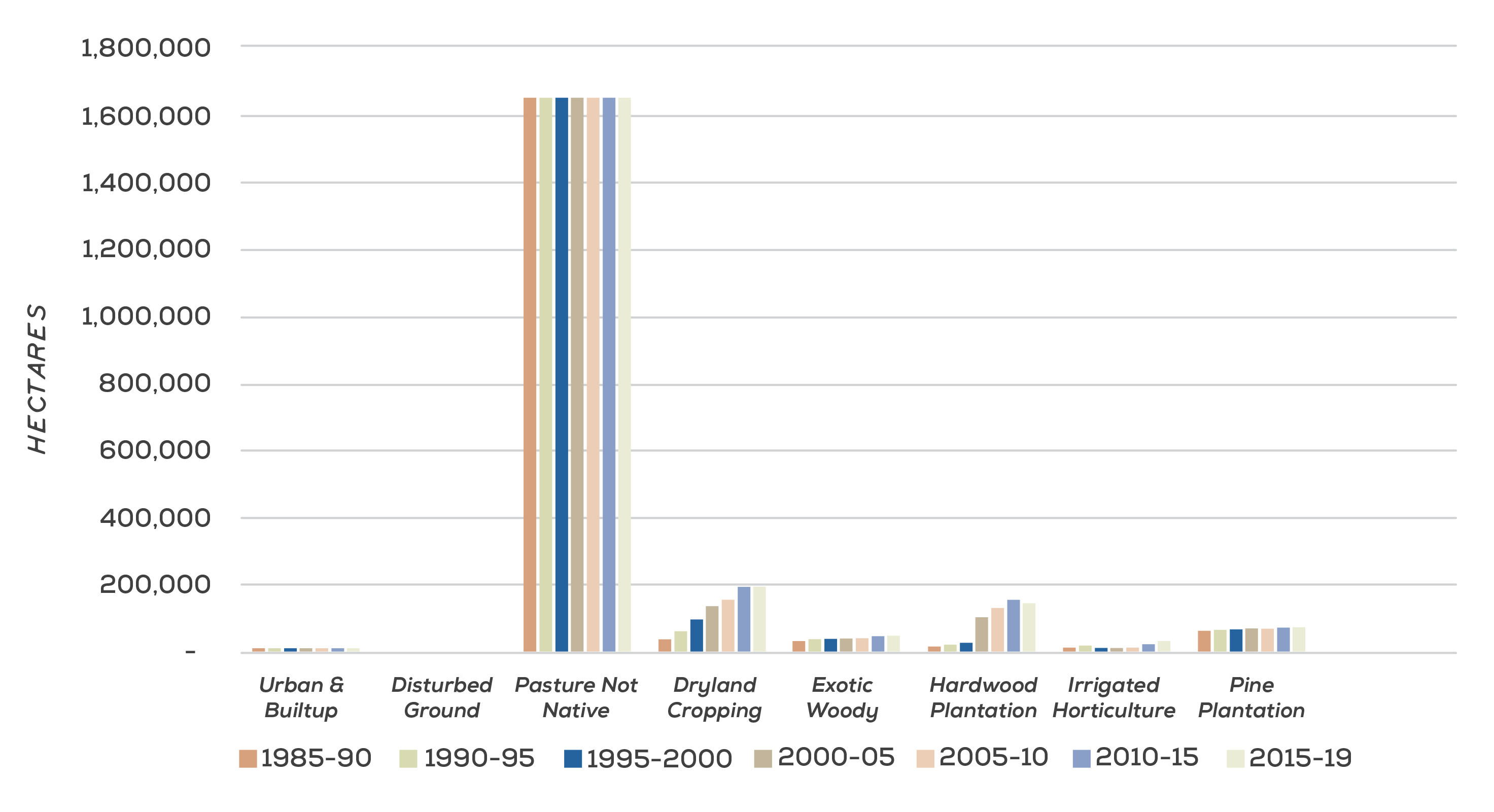
Over the past 30 years, the area of land under pasture has declined, and area under cropping and hardwood plantation has increased (see Figure 1 and video below)3. Despite the significant increase in area of dryland cropping since 1985-90, the area under cropping has plateaued over the past 10 years, at around 200,000 ha. The area under hardwood plantation peaked in 2010-15, and declined between 2015 and 2019. The area of land under pine plantations has remained relative stable over the past three decades, while the area under irrigated horticulture has gradually increased. Further analysis on the key drivers behind these trends is provided below.
Conservation estate
The 2018 State of the Parks report examined the condition and change since 2013 of 31 reserves in the Glenelg Hopkins region. While no reserves were classed as in ‘excellent’ condition, 58% were assessed as being in ‘good’ condition. Of these, most had maintained their condition, except for the Mortlake Common Flora Reserve, which had declined, and Mount Buangor State Park, which had improved. Thirty-five per cent of reserves were assessed as being in ‘fair’ condition, with three in continued decline (Bats Ridge Wildlife Reserve, Gariwerd (Grampians National Park), Lake Linlithgow and Bullrush Swamp Reserve). The Black Ranges State Park was the only reserve identified to be in ‘poor’ condition, with its condition having continued to decline since 2013. Where decline in condition was identified across the region’s reserves, key drivers included invasion of weeds and pest animals, bushfire, inappropriate water regimes, over-abundant native animals, tree dieback and impacts from visitors4. See Figure 2 for the spatial extent of conservation reserve in the region and Figure 3 for the area of permanent protection within the region5.
Cropping
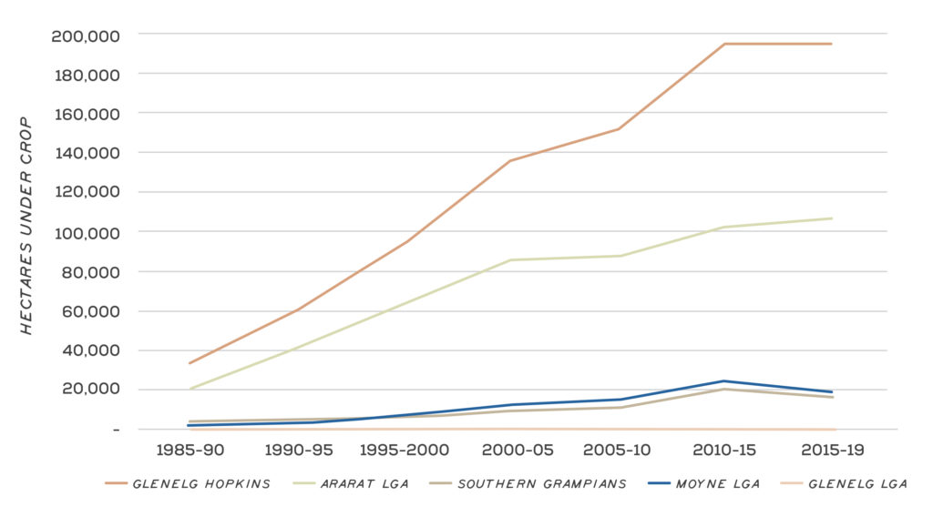
The area of land under cropping has increased significantly over the past 30 years, from around 34,000 ha in 1990, to almost 200,000 ha in 2018-19 (12% of regional agricultural land use)6. This transition from grazing to cropping has been particularly evident in the north-east of the catchment. The expansion of cropping has been supported in some areas by the use of raised bed techniques, which has enabled cropping to be adapted to historically high rainfall zones. The significant increase in cropping in the early 1990s was partially linked to the collapse of the wool price. Since that time, positive economic returns and other factors have encouraged farmers to transition into cropping, either as a mixed operation, in combination with grazing, or as a single enterprise. The Ararat Local Government Area (LGA) has experienced the largest change of land use. Since 1990, just under 15,000 ha of permanent pasture per year was converted to crop (Figure 4 and video below)7.
Grazing
Grazing, predominately for sheep, beef and dairy cattle, is the major land use within the Glenelg Hopkins region. Dryland grazing accounts for around 76% of agricultural land use, with 88% on improved pasture. The agricultural commodities produced by grazing enterprises account for more than 80% of agricultural commodities produced from the region, by gross value. There has been a decrease in land used for broadacre grazing since the 1990s, with permanent pasture land changed to accommodate growth in dryland cropping and hardwood plantations (see video)8.
Plantation forestry
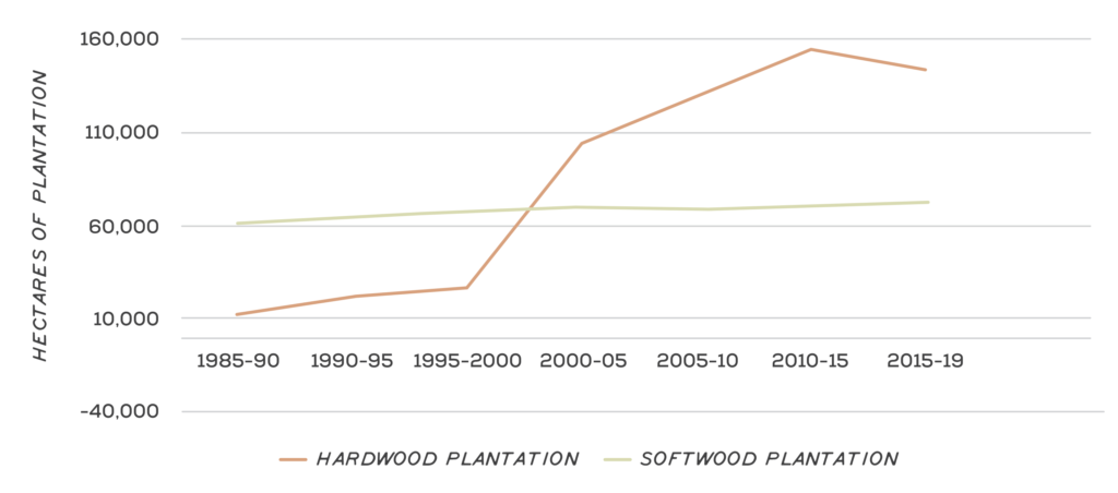
The area of softwood (mostly Pinus radiata) plantations in the region has remained relatively stable over the past 30 years, at around 60,000-70,000 ha9. The area used for hardwood plantations has increased significantly. The involvement of Managed Investment Scheme (MIS) companies in the late 1990s drove a rapid increase in the area under hardwood plantations (blue gums), and reduction in land used for permanent pasture. This change in land use is particularly evident in the Glenelg catchment area, where timber plantations in the Bahgallah, Dartmoor, Dergholm, Hotspur and Nareen areas increased by 730%, from 1,421 ha to 10,354 ha10. Changes to MIS incentives from 2006, and the 2008 global financial crisis, have slowed the expansion of hardwood plantations. Expansion of hardwood plantations appears to have peaked in 2015 at around 140,000 ha (Figure 5 and video below)11. Since that time, the industry has moved to consolidate hardwood resources, limiting locations to areas that can be profitably managed, harvested and transported. The conversion of land to pasture after harvest of hardwood plantation has become more common in recent years.
Major threats and drivers of change
Changes in land use driven by climate and commodity values
Regional land use is heavily driven by climate and economic factors. Prior to the wool price reserve crash, wool production was the dominant enterprise within the catchment. Ongoing low wool prices have led to a decline in the wool industry and an increase in prime lamb production. This has also contributed to a transition to cropping in the north-east of the region12. In more recent years, the downturn in milk prices in 2017 has had a significant impact on the sector, with many dairy enterprises in the region’s south-east converting to beef production.
Available land use data suggest the area under crop may have peaked in 2015. However, a predicted 2021 increase of 11% in world wheat prices, 15% rise in export barley and 18% rise in oilseed prices may encourage renewed expansion of land under crop13. The corresponding prediction of a 23% decrease in prices for wool, due to lower demand, may encourage this trend14.
Changes in regional land use are also predicted as a result of climate change. For example, a technical report by Deakin University in 2017 modelled a range of scenarios for broader acre cropping, under a changing climate. The report concluded that:
“The modelling indicates a likely shift of the traditional cropping zone from the northeast corner of the catchment further south and west, following the projected rainfall decline. Such a shift may increase suitability in the south, specifically for winter cropping commodities sensitive to waterlogging, but the equivalent decrease of precipitation is likely to cause water shortages and subsequent suitability decline in the traditional cropping zone around Ararat, Tatyoon, Lake Bolac and Streatham.” 15
Raised bed cropping
Adoption of raised- bed practices has proven to be an effective method for cropping farmers to move onto land previously too wet in winter for crops. The practice began in southern Victoria in 1995; and carries several environmental risks, including releasing greater amounts of run off than conventional cropping and pasture systems.16 Field measurements have shown that the volume of run-off can be increased by 100%, when compared to standard cropping systems.17 This can result in increased erosion risk, particularly when run-off flows into drains not built for higher volumes of water or flow rates, flooding and damage to public infrastructure.
Plantation forestry risks – water use
A study of plantation forestry water use in south-west Victoria concluded that “all plantations used all available rainfall during the monitoring period”, and “all plantations accessed soil water from at least 4 m to 6 m depth and probably from deeper than 6 m depth”18. While these conclusions demonstrate the potential benefits of plantations to reduce salinity risks due to rising water tables, the impacts of plantations on wetlands and other groundwater dependent ecosystems can be damaging. In addition, high utilisation of rainfall by plantations greatly reduces opportunity for surface water flow into rivers, as well as decline of groundwater base flows, due to groundwater uptake by plantations.
The continued expansion of cropping is expected across the region
Raised beds enable cropping in wetter areas
Photo: Southern Farming Systems
Reversion of bluegum plantations to farm land
Photo: Don Price
Centre pivot irrigation from groundwater
Reversion of blue gum plantations to pastures
Some harvested areas of blue gum plantations within the region are not being used for a second rotation and the land is being sold for farming. Returning these areas to pasture or cropping remains a challenge due to the potentially high costs involved.
While available data suggests hardwood plantation forestry has been reducing in land area since around 2015, the recently released Australian Government national forest industries plan may enable renewed industry growth.
Centred around Regional Forestry Hubs (locally at Mt Gambier), the plan seeks to reduce barriers to forestry expansion by realising opportunities in dual-purpose agroforestry on farm land, value-adding and diversity of forestry products, enabling forestry to fully participate in the Emission Reduction Fund, and reviewing legislative restrictions to plantation expansion19.
Expansion of irrigator sector
There has been growing interest in irrigation within the region’s agriculture industries in recent years. While the region has long had irrigation, the rate of new development of irrigation has historically been quite low, with only one or two Section 51 licence applications per year. However, applications increased to four in 2017/18 and 2018/19, and a recent Expression of Interest for Dilwyn Aquifer water attracted about 20 applications.
There are no declared irrigation areas in the Glenelg Hopkins Region. Irrigation in the region is primarily concentrated in two areas: within 30-40 km of the coast from east of Warrnambool to Tyrendarra, and within 20 km of the Victoria-South Australia border north of Nelson up to Lake Mundi. Other irrigation is dispersed where localised water resources are available.
While there are economic and social benefits in utilising the regions water resources for primary production and secondary processing, there are a range of potential threats associated with irrigation, including:
- Direct destruction of habitats during development.
- Changed hydrology due to irrigation-induced rainfall runoff and tailwater, or through inappropriate drainage.
- Changed hydrology due to over-extraction of the water resource.
- Changed water quality due to inefficient irrigation practices and poorly designed drainage/buffer zones.
Outcomes and priority management directions
Outcomes and priority management directions have been developed to show what success looks like for integrated catchment management (ICM) across the Glenelg Hopkins region. Below is the 20 year (long-term) outcome for land use. Within these are the proposed six-year outcomes and priority management directions to be achieved within the life of this strategy. The priority management directions are identified across the adaptation pathway stages of resilience, transition and transformation (see RCS approach for more information). Lead and key partners involved in delivery are also outlined.
By 2042, land managers are supported to manage land and water within its capability
| 6 year outcome, by 2027... | Resilience management priority | Transition management priority | Transformation management priority | Lead or coordinating responsibility | Delivery partners |
|---|---|---|---|---|---|
| There is increased understanding and protection of Aboriginal cultural values and heritage across the landscape and throughout the community. | Conduct survey to establish baseline information around understanding and protection of Aboriginal cultural values and heritage across the landscape. Government, agencies and authorities partner with Traditional Owner groups to undertake communication, education and engagement to increase community awareness of Aboriginal cultural heritage across the landscape. | Traditional Owners lead the identification and protection of tangible Aboriginal cultural heritage, including heritage surveys. Cultural heritage surveys led by Traditional Owners are proactive, not only reactive, to development. | Traditional Owners lead projects that support intangible Aboriginal cultural heritage recording and protection. Support Traditional Owner purchase of cultural sites where appropriate. Investigate options to have registered cultural heritage sites included on S32 docs. | Gunditj Mirring Traditional Owners Aboriginal Corporation and Wadawurrung Traditional Owners Aboriginal Corporation. Additional partners TBD. | DELWP, Parks Victoria, Glenelg Hopkins CMA |
| 500 land managers have improved knowledge and awareness of land capability. | Conduct survey to establish baseline information for land manager knowledge and awareness of land capability. Develop education and awareness programs aimed at increasing knowledge of region land capability. | Deliver programs that increase land managers' knowledge of land capability. | Continue to refine and update land capability information and data considering the impacts of climate change. | Glenelg Hopkins CMA | DELWP, Agriculture Victoria, Local Government, agricultural industry groups, Landcare groups |
| 200 land managers are supported to manage their land to meet duty-of-care and legislative obligations. | Conduct workshops that provide opportunity for land owners to increase capacity to manage land within its capability. Partner with government and industry to align plans, strategies and targets for land. e.g. nutrient management, carbon management. Land managers (including lifestyle and absentee owners) are educated about their duty of care and obligations for appropriate land management through skills and training opportunities. | Information about emerging land use options is shared with the regional community. Support community groups to deliver programs that increase knowledge and build capacity of land managers in sustainable agriculture, including Landcare. Deliver programs that support land managers in informed decision making. | Appropriate planning controls are implemented to ensure land use aligns with land capability, including updated planning schemes. Strategic agricultural land has been identified and has the necessary planning controls for protection. Protected species, habitats and cultural heritage assets are recorded on title. | Glenelg Hopkins CMA | Agriculture Victoria, DELWP, Local Government, agricultural industry groups, Landcare groups |
| Land managers have increased understanding of sustainable water availability and land capability for irrigation. | Conduct survey to establish baseline information for land manager understanding of sustainable water availability and land capability for irrigation. Conduct salinity and surface water monitoring. Support existing and potential irrigators to understand land capability on-farm. Undertake regular surveys and mapping of the irrigation industry in the region to understand and communicate water use trends. | Support regional research on best practice irrigation. Undertake promotional activities to increase land holder awareness of the web-portal, 'Visualising Victoria's Groundwater'. | Land managers are supported in the use of new technology to monitor and manage water resources on farm. Research and develop user friendly communication tools such as maps to identify areas of sustainable water availability that align to land highly suitable for irrigation. | Southern Rural Water, Great South Coast Food and Fibre, Glenelg Hopkins CMA | Agriculture Victoria, DELWP, agricultural industry groups, universities |
| Irrigators are increasingly supported to improve water use efficiency and irrigation practices | Develop and implement Irrigation Development Guidelines. Undertake compliance inspections of irrigated properties under development. Programs are delivered to support land manages to increase water use efficiency. | Demonstrate the public benefits of investment in on-farm irrigation practice improvements. Deliver best practice irrigation training. Support farmers to understand how to maximise water use and energy efficiency for irrigation. | Support landholders to improve their irrigation efficiency. Support irrigators to develop whole farm plans. | Glenelg Hopkins CMA | Agriculture Victoria, Southern Rural Water, DELWP, agricultural industry groups, |
| Three forestry managers are supported to enhance integrated catchment management outcomes across plantation estate | Education and capacity building programs supporting integration of forestry. Engagement with forest managers to identify shared goals. Ensure forestry companies understand their land managment obligations (e.g. requirements for works on waterways permits and licence conditions). | Support land managers to adopt agroforestry practices for economic, carbon sequestration and biodiversity benefits. Landscape pests and plant control. Support land managers in change from forestry to another appropriate land use Support forest managers to undertake opportunities to integrate threatened species protection into forestry plantations Support forest managers to understand water use and impacts of forest plantations | Forest managers are supported to achieve integrated catchment management outcomes. | Glenelg Hopkins CMA | Green Triangle Forestry Industries Hub, plantation forestry companies |
| Eight opportunities have been investigated for a range of market based instruments, policy, incentives, and market drivers, to support land managers to adopt improved land management practices and value on-farm biodiversity | Education and capacity building opportunities are provided to support land managers in valuing on-farm biodiversity, and options that are available. | Investigate and pursue options to incentivise adoption of improved land management practices. Local government has been encouraged to include rates relief for land reserved for conservation. | Landholders are rewarded for undertaking best practice/environmental outcomes. | Glenelg Hopkins CMA | Agriculture Victoria, agricultural industry groups, Meat and Livestock Australia, Local Government |
Key strategies and plans that relate to the delivery of land use outcomes include:
- National Soil Strategy
- Glenelg Shire Council – Council Plan 2017-2021
- Warrnambool Council Plan
- National Farmers Federation – 2030 Roadmap
- Drought Resilience Funding Plan for 2020 to 2024
- GRDC Strategic Plan 2005-2025
- Great South Coast Regional Partnership – Road Map 2018
- Growing What is Good Country Plan, Voices of the Wotjobaluk Nations
- Meerreengeeye ngakeepoorryeeyt, Eastern Maar Country Plan
- Ngootyong Gunditj Ngootyong Mara South West Management Plan
- Paleert Tjaara Dja, Let’s make Country good together 2020-2030, Wadawurrung Country Plan
- 2030 Dairy Sustainability Goals and Targets
- Drought Resilience Funding Plan for 2020 to 2024
- Southern Grampians Shire Council Plan 2017-2021
- Strong, Innovative, Sustainable: A new strategy for Agriculture in Victoria
- food+fibre Great South Coast Strategic Plan 2021-2023
- Green Triangle Forestry Industries Hub Action Agenda
- National Forest Industries Plan – A billion tress for jobs and growth
- Glenelg Hopkins Climate Change Strategy
- Victorian Government Climate Change Strategy
- Agriculture Sector Pledge
