2050 Vision
Empowered communities nurturing a rich and connected landscape for all – today, tomorrow, together
Our region
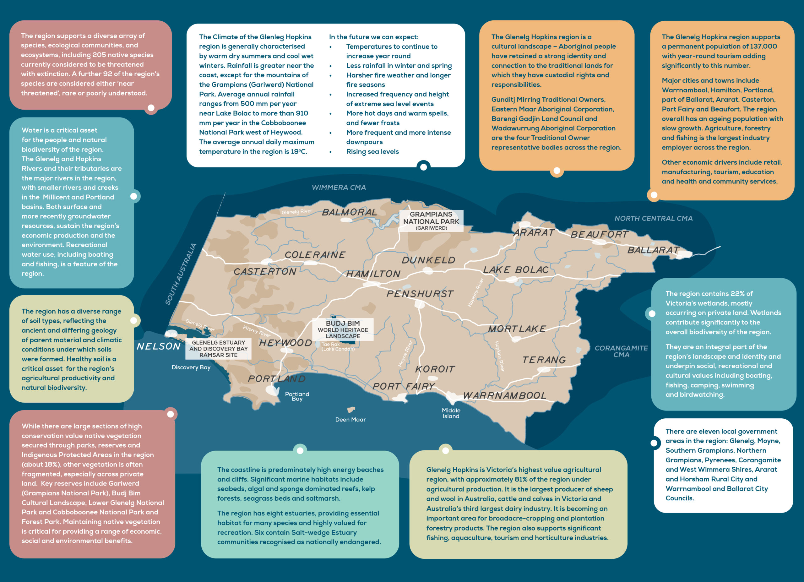
The Glenelg Hopkins region lies south of the Great Dividing Range in Victoria’s south-west. It is a varied and productive region renowned for its agricultural industry, rich cultural heritage, scenic beauty, dramatic coastline and unique biodiversity. The region covers 26,910 km2, 220 km of coastline and extends three nautical miles out into the sea. It is characterised by flat volcanic plains in the south, while the Dundas Tablelands, Gariwerd (Grampians) and Central Highlands dominate the north. Landscapes of the region include plains, hills and rugged ranges, bushland, native grasslands, wetlands, coastal cliffs, kelp forests, seagrass beds and reefs.
Natural features of national and international importance include:
- UNESCO World Heritage listed Budj Bim Cultural Landscape.
- 6 National Parks, including the National Heritage listed Gariwerd (Grampians National Park).
- 2 Ramsar sites – Lake Bookar and Glenelg Estuary and Discovery Bay.
- 3 Key Biodiversity Areas (KBA) – Discovery Bay to Piccaninnie Ponds KBA, Yambuk KBA and Port Fairy to Warrnambool KBA.
- Moyjil (Point Ritchie) – culturally significant headland at the mouth of the Hopkins River in Warrnambool.
- Victorian Heritage River listing for the Glenelg River estuary.
- Australia’s most extensive volcanic province – Kanawinka Geopark.
- The iconic red-tailed black cockatoo, orange-bellied parrot, Glenelg spiny cray, variegated pygymy perch, blue whale and spiny rice flower, and more than 200 other threatened or listed migratory species.
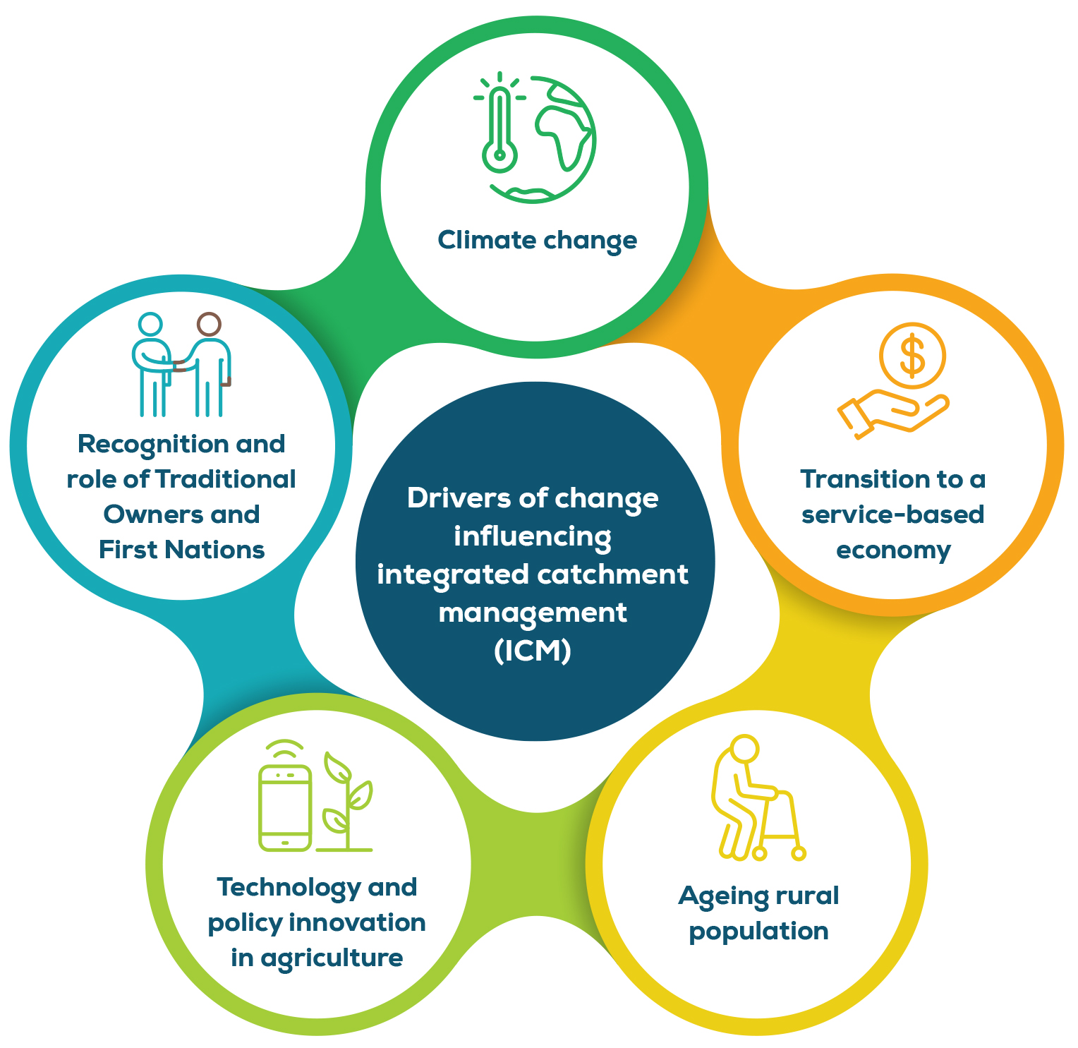
Drivers of change
Drivers of change impact rural and regional communities and their economies. This in turn, impacts integrated catchment management. Climate change, the recognition and role of Traditional Owners and First Nations, the transition to a service-based economy, an ageing rural population and technology and policy innovation in agriculture are the key drivers of change in the Glenelg Hopkins region1.
Climate change
Climate change results in impacts such as increased drought, flooding and bushfire incidence and severity, changes in water quality and availability, reduced ecosystem health and condition, and poorer regional liveability and community resilience.
Recognition and role of Traditional Owners and First Nations
The shift in recognition and role of Traditional Owners and First Nations has seen legislative and policy advances in land and water management through the integration of Traditional Ecological Knowledge and cultural aspirations into planning frameworks and policies.
Transition to a service-based economy
Transition to a service-based economy is leading to declining farm and rural populations, the migration of young people to larger urban centres, increased urban population growth and increasing recreational demand on regional environments by urban populations.
Ageing rural population
Ageing rural populations are resulting in changed service demands, employment transition to health and community services, and declining involvement in volunteering and community groups.
Technology and policy innovation in agriculture
Technology and innovation in agriculture includes a greater influence of international markets. It is leading to increased scale of production and intensification, particularly in cropping and horticultural industries, increases in corporate farming, and the replacement of labour with technological capital, which is developing at a rapid rate.
Regional challenges and opportunities
The following are broader themes that were identified through community consultation2. These themes include challenges and opportunities for integrated catchment management (ICM) in the Glenelg Hopkins region, and are either a direct result of or are influenced by the drivers of change mentioned above.
Climate impacts
The changing nature of our climate and rise in extreme weather events, such as floods, droughts and fires, are acknowledged both nationally and internationally as a growing risk. Climate change is already having negative impacts on the social-ecological systems in our region, increasing vulnerability, and threatening ecological health, human health and livelihoods3. It affects us all. Responding to climate change in the Glenelg Hopkins region requires solutions that are identified, owned and driven by the community4,5.
Regional sustainability
The social and economic future of south-west Victoria is directly linked to the health and maintenance of the region’s natural resources. For example, the Glenelg Hopkins region is Victoria’s highest value agricultural region, with 81% of the catchment agricultural land reliant on healthy soils and water availability6. Tourism is based on the region’s natural and cultural values, including recreational use of waterways, national parks and coastal zones. Supporting individual connections to the environment through access to green and blue spaces is also central to community health and well-being7.
Continuing to sustain a healthy and resilient region requires an understanding of the way community and visitors to the region use and interact with the environment, and subsequent adaptation of approaches to ICM engagement and participation. For example, regional partnerships that combine socio-economic, cultural and environmental futures need to be pursued. This includes recognising any tensions and opportunities between historical and new land use changes and practices across the region, as well as the opportunities that cross-tenure and cross-border collaborations provide.
Natural environment
The Glenelg Hopkins region has significant, but often threatened, biodiversity found in unique and complex systems on land, in soil, water, estuaries and the sea. Numerous flora and fauna species have already become extinct and many more are threatened. A major threat to biodiversity across the region is the continued loss of habitat and fragmentation from land clearing and land use change8. Invasive pest plant and animal species are also a threat through competition, displacement and predation. Climate-induced stress and increased visitor numbers can accelerate the introduction and spread of invasive species. Climate change is affecting habitat more broadly and native species must either adapt or migrate to more favourable areas if they are to persist9.
The interconnected nature of ecosystems means that any continued loss of habitat and species has a knock-on effect on the ecosystem functions and benefits that biodiversity provides. The community needs to be prepared for inevitable landscape change. It also needs to actively participate in supporting natural environments to adapt. Continued declines have impacts on culturally significant species for Traditional Owners. Effective ICM needs to consider differing community values for and uses of the natural environment, and by extension improve people’s awareness and understanding for greater community contribution to its protection10. Strengthened partnerships with Traditional Owners, who have cultural obligations to care for their Country, which value traditional knowledge and cultural practices, is an important direction for landscape management and resilience.
Photo: Southern Grampians Shire
Photo: Southern Grampians Shire
Agricultural stewardship
Healthy soil is an essential asset for agricultural industries operating in the region, predominantly horticulture, cropping, dairy and livestock. Within the Glenelg Hopkins area, soil has have been recognised for their its very high productivity potential when appropriately managed. Soil acidification, loss of soil organic carbon matter and hillslope erosion by water are issues in the region11. A better understanding of soil and the adoption of improved agricultural land management practices over time, has led to seen the productive capacity of the region’s soil improvinge. With drivers such as climate change, agricultural intensification and regional land use change, soil health needs to remain a key regional priority12. Linked to soil health is biodiversity health. Improvements in the protection and management of native habitat, including wetlands, grasslands and along waterways, has positive effects for agricultural production. With most of the land in the Glenelg Hopkins region under agricultural production, the public benefits of private agricultural stewardship need to be recognised and supported13.
Coastal landscape
The coastal area of the Glenelg Hopkins catchment contributes significantly to the economic, cultural, environmental and recreational life of regional communities. Eighty per cent of Victorians rate the marine and coastal environment as the most important natural feature of Victoria14. Coastal areas, particularly around Warrnambool and Port Fairy are experiencing unprecedented increases in population and tourism activity. Balancing public use and development with environmental and cultural protection of coasts and estuaries is a major challenge. Climate change will add further challenges and pose serious impacts on biodiversity and ecosystem health within marine and coastal areas15.
Water security
Water security will be a key driver for capital investment and land-use change in the region. Sustainable management of the region’s groundwater and surface water helps underpin the forecast residential, agricultural and industrial development of the region. Periods of drought and flooding are significant risks for the region and are becoming more frequent under climate change16. Fresh water is one of the region’s most important natural assets and a resource at enormous risk. Major threats to both surface and groundwater include pollution from farming activities, stock access to waterways, salinity, erosion, pest plants and animals, and overuse. Other key pressures on water supply in the region include reduced rainfall and change in seasonality of rainfall, increased demands for water due to changing farming practices, reduced surface flows and increased use of groundwater. These pressures, combined with land use change can threaten habitat (particularly wetlands)17. Opportunities continue to exist through improved waterway health, sustainable irrigation, securing environmental water for the Glenelg River and exploring Traditional Owner rights and interests in cultural water entitlements.
Ben Church (Budj Bim Rangers) starting a cultural burn
