Sweeping hills and windswept plains
Vision: A working landscape of diversity and production from the foothills of the Grampians across the grasslands and wetlands of the northern volcanic plains
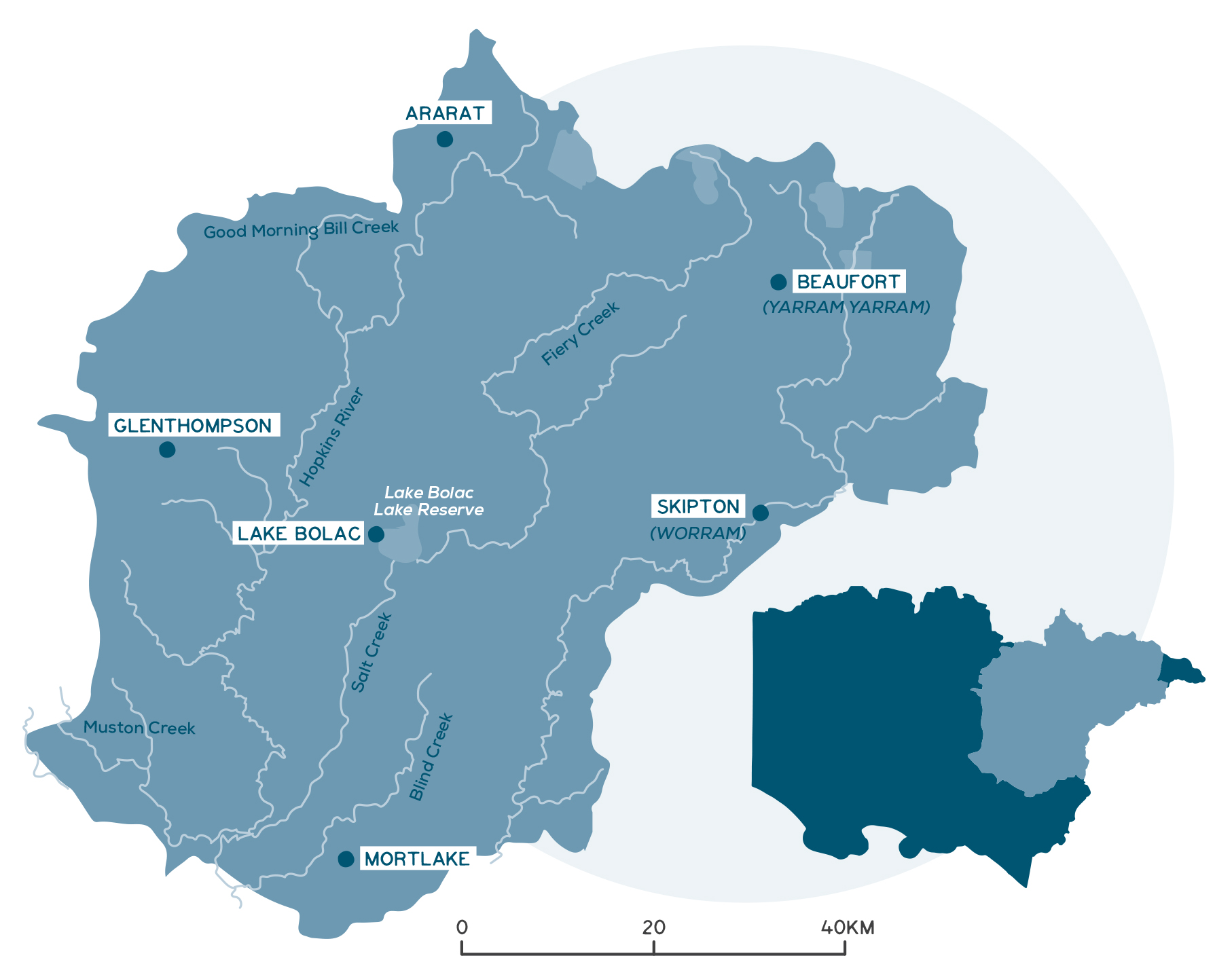
This local area is in the north-eastern half of the Glenelg Hopkins region with a population of about 20,000 people. The main towns are Ararat, Beaufort, Glenthompson, Lake Bolac, Skipton and Mortlake.
Traditional Owner organisations managing country include Eastern Maar Aboriginal Corporation and Wadawurrung Traditional Owners Aboriginal Corporation.
Ararat Rural City forms a gateway to important tourism destinations such as Gariwerd, Pyrenees Ranges, Mt Langi Ghiran and Lake Bolac.
Agriculture and forestry are the largest industry employers in the area.
Key Landcare networks include the Upper Hopkins Land Management Group, Beyond Bolac Community Action Group, Upper Mt Emu Creek Landcare Network and Basalt to Bay Landcare Network.
Local Government Authorities include Ararat Rural City, Pyrenees Shire, Moyne Shire and Corangamite Shire.
A snapshot of the North Eastern Volcanic Plains
- Key towns include Ararat, Beauford, Lake Bolac, Skipton and Mortlake.
- Agriculture and forestry are the main industry employers.
- Declining and ageing rural population, other than in Mortlake, which is growing.
- The area has converted from a predominately grazing to cropping district.
- Native vegetation covers 16% of the area.
- This area is a biodiversity hotspot with more than 3,500 wetlands (almost 50% of the Glenelg Hopkins total) and highest quality remnants of native grasslands.
- Key reserves include Woorndoo Common, the Wickliffe Cemetery Roadside Reserve, Ben Major Conservation Reserve, Langi Ghiran State Park and Mount Buangor State Park.
- Key waterways include Hopkins River, Mount Emu Creek and Fiery Creek.
- Fiery Creek is the boundary between Wadawurrung and Eastern Maar Traditional Owner groups.
- Lake Bolac is of cultural and recreational significance.
- Increased cropping is the biggest threat to wetland and native grassland extent. Climate change is also a significant diver of change. Declines in roadside burning and pest plants also affect grassland health.
Detailed overview
Dominated by the vast volcanic plain, this local area, which was predominately grazing country, is a place of changing land use. Varying rainfall patterns and economic signals have seen the expansion of cropping over the past 30 years.
Predicted climate trends forecast higher temperatures and reduced annual rainfall. This will continue to favour cropping expansion further south over the next decade or two. From 2018 to 2019, gross value of cropping commodities in the Glenelg Hopkins region increased by 122%. Cropping is more amenable to mechanisation than grazing enterprises. With lower labour demands than other industries, the increase in cropping is both a response to workforce shortage and contributor to rural depopulation.
Sheep and wool production remain key industries, with mixed-farm enterprises a common sight. The more northern section is famous for its viticulture and wine industry, as well as manufacturing and forestry. The promise of a reliable freshwater supply through the East Grampians Pipeline, sourced predominately from Lake Fyans, will open new businesses opportunities in the region. In addition, Stavely to the east of Glenthompson is considered a prime candidate for mining of copper and gold.
This local area has more than 3,500 wetlands, almost 50% of the Glenelg Hopkins region’s wetlands. It also has the highest diversity of wetland types, with saline and freshwater systems well represented and permanent and temporary wetlands a feature. However, this area is particularly important for temporary freshwater wetlands, which make up 40% of the wetlands.
The North Eastern Volcanic Plains local area is a hotspot for biodiversity. In addition to the highest density of seasonal herbaceous wetlands in the Glenelg Hopkins region (more than 800), it has some of the highest-quality remnants of natural temperate grassland that remain on the Victorian Volcanic Plains (VVP). Both these ecological communities are critically endangered.
Native vegetation contributes to 16% of land cover in this area and has declined by 20% since 1990. This has been largely driven by the loss of native grassland, with extent declining by 23% since 1990. However, for high-quality roadside grassland that have been regularly burnt, floristic change since the 1980s has been minimal.
The section of the Dundas Tablelands in this area contains highly significant patches of native grassland, such as the Woorndoo Common and the Wickliffe Cemetery Roadside Reserve. These areas provide essential threatened species habitat, including habitat for nationally endangered daisies such as the button wrinklewort and hoary sunray. Fifty-seven threatened species have been recorded within the North Eastern Volcanic Plain. These include 27 fauna species, such as the golden sun moth (critically endangered), striped legless lizard (endangered) and growling grass frog (endangered), and 30 flora species, including nationally listed species such as the spiny rice-flower (critically endangered).
The Central Victorian Uplands include the Ben Major Conservation Reserve, the Langi Ghiran State Park and Mount Buangor State Park. These reserves provide habitat for several endangered species and local endemics, and form part of the Grampians to Pyrenees (G2P) biolink – a landscape-scale project aiming to improve the connectivity and resilience of the landscape, especially ensuring that larger-scale ecological patterns and processes are linked to local-scale actions. Mount Buangor State Park is part of an Aboriginal cultural landscape in the traditional Country of the Eastern Maar Peoples.
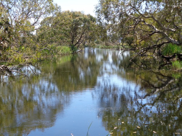
The main waterways include the Hopkins River, Mount Emu Creek and Fiery Creek. The Hopkins River is a major waterway draining the eastern part of the region. Mt Emu Creek is the main tributary of the Hopkins River and contains reaches with relatively intact remnant vegetation and deep permanent pools providing drought refuge for threatened aquatic species. Several reaches within the Fiery Creek system are of ecological significance and support social and economic activity. Good examples of remnant creek line grassy woodland and riparian woodland occur within the area. Other waterways in this local area include Muston Creek (which has significant populations of the newly listed south-west Victorian blackfish), Salt Creek, Blind Creek, Baillie Creek and Burrumbeet Creek.
Fiery Creek
Fiery Creek is highly significant to Aboriginal people. It forms the boundary between Eastern Maar Aboriginal Corporation and Wadawurrung Traditional Owners Aboriginal Corporation Registered Aboriginal Party areas. In Wadawurrung language Fiery Creek is Boringayallar meaning ‘flood to carry away trees’.
The lower sections of the creek, especially Lake Bolac, have high cultural and recreational values and are popular for camping, walking, boating and fishing. The Lake Bolac Eel Festival is a well-known cultural and environmental festival held biannually on the foreshores of the Lake and is an important event for the regional economy. The local area more broadly, is significant for Traditional Owners with evidence of cultural heritage spread throughout the landscape.

Challenges and threats
Declines in groundcover and soil organic carbon levels have accompanied changes to land use across the Volcanic Plain. Adoption of conservation cropping practices such as stubble attention and minimum, or no, tillage can help reverse these trends, with a target of a minimum 70% annual groundcover in cropping regions. Low-fertility, granite sand surface soils of the Ararat Hills remain at risk of erosion. Implementation of land management practices, such as deferred grazing, to maintain groundcover and reduce erosion risks, should be maintained. Soil erosion in the uplands and soil acidification more broadly are risks associated with farming intensification. Salinity is also both a natural feature and a result of historical land management practices. Though declining annual rainfall has reduced risk, monitoring for incidence of dryland salinity must be maintained. Action to re-establish woodlands and declining annual rainfall help reduce secondary salinity risks.
The clay soils of the volcanic plain are also susceptible to compaction and surface ponding after rain – factors that can hinder rooting depth and persistence of crops and pastures.
With the increasing conversion of grazing land to cropping, this area has undergone significant declines in native vegetation cover in seasonal wetlands (10% loss since 1990) and scattered native trees (6% loss since 1990). Cropping in a large cluster of EPBC-listed seasonal herbaceous wetlands south-east of Gariwerd increased by 40% between 2010 and 2016. Despite the large number of wetlands in this local area, few have been assessed in the Index of Wetland Condition (27 in total). Of those assessed, the more permanent wetlands and lakes were typically in better condition. Two-thirds of temporary marshes and meadows assessed were in moderate or poor condition.
Flooding is also a threat to townships. For example, Ararat Rural City has a history of flooding, including a significant flood event in January 2011. This flood impacted the township of Wickliffe and damaged vast extents of rural areas, including buildings and erosion of creek lines. Local flood management plans and studies help manage the ongoing risk to community wellbeing, infrastructure and the natural environment. Other towns at risk include Beaufort and Skipton.
Drainage, the diversion of water, reductions in rainfall and increasing evaporation all affect the condition of waterways and wetlands. Water availability will be a key issue under climate change, particularly as land uses changes are explored across this local area. The long-term water availability in the Hopkins River has declined by around 6% against benchmarked flows set in the Western Region Sustainability Water Strategy. Annual average gauged flow shows a 60% decline (Hopkins River at Hopkins Falls) from pre-1996 to 1997-2019. Agricultural fertiliser use associated with cropping expansion can also increase nutrient levels in wetlands and rivers. Water quality trends across this area already show increasing levels of nitrogen and phosphorous, and turbidity.
Climate change is likely to drive significant changes in the future. Forested areas in the north may experience increasingly frequent and severe bushfires. Seasonal herbaceous wetlands are likely to become increasingly dry, triggering cascading impacts with a perceived opportunity to expand cropping into these areas. For native grasslands, elevated temperature and carbon dioxide may increase biomass production of kangaroo grass while reducing growth of co-occurring species. Plant recruitment may be resilient to changes in the amount of annual rainfall, but sensitive to increases in temperature and changes in rainfall seasonality. To some extent, it may be possible to mediate impacts of climate change on grasslands through an appropriate disturbance regime.
High-quality roadside grasslands are at significant risk through a decline in burning, with local CFA volunteer fire brigades being challenged by changes in social demographics, land use and regulatory processes.
Some common weeds across the area include gorse, white radish and horehound. Phalaris, an introduced pasture species, presents as a primary weed threat across the area. It rapidly out-competes native species and alters fire behaviour. For example, phalaris-dominated roadsides accumulate higher levels of biomass, burn with three times the intensity and are far more unpredictable than fire on native-dominated roadsides.
Community priorities and interests
The outcomes and priority management directions for the strategy are detailed under each theme, these set the strategic framework for the strategy.
Although all outcomes in the RCS are a priority across the region, each local area has different priorities for implementation based on the local values, threats, and community priorities. The strategy will be implemented via specific projects, or the core activities of a range of agencies, groups and local people involved in managing and conserving natural resources and biodiversity values.
Community priorities and interests that relate to the North Eastern Volcanic Plain local area are outlined below. These priorities and interests have been raised by community and partners through the RCS engagement process. These are also reflected in the priority management directions under each theme and together they guide the implementation of the RCS within the different local areas.
Traditional Owner groups
Further detail on Traditional Owner groups in this local area can be found on their individual pages – click the names below:
* Eastern Maar Aboriginal Corporation
* Wadawurrung Traditional Owners Aboriginal Corporation


