From grassland plains to the wild coast
Vision: Connecting communities to protect, restore and enjoy the natural environment across the southern volcanic plains to the shipwreck coast, while balancing the productivity of the land
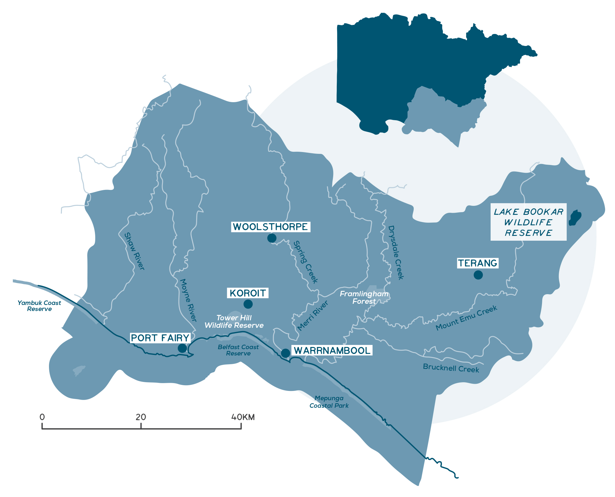
This local area is in the south-eastern section of the Glenelg Hopkins region. It has the largest population, with about 55,000 people. Warrnambool is the largest urban centre in south-west Victoria, and the main service centre for retail, business services, health and education. Other towns include Koroit, Port Fairy and Terang. There is modest population growth across this local area.
Traditional Owner organisations managing country include Eastern Maar Aboriginal Corporation and Gunditj Mirring Traditional Owner Aboriginal Corporation.
Agriculture, forestry and fishing is the largest industry employer outside of Warrnambool City, where health care and social assistance is the main industry employer.
Key Landcare networks include the Basalt to Bay Landcare and the Warrnambool and District Landcare Networks.
Local Government Authorities include Corangamite Shire, Moyne Shire and Warrnambool City Council.
Moyne estuary, Port Fairy
A snapshot of the South Eastern Coastal Plains
- Key towns include Warrnambool, Koroit, Port Fairy and Terang. Warrnambool is the largest urban area in south-west Victoria.
- Agriculture, forestry and fishing are the largest industry employers outside Warrnambool, where health care and social assistance are the main industry employers.
- Ageing rural population, with competition for labour and skills.
- Dairying is the dominant agricultural land use, contributing to the region being one of Australia’s most important milk producers.
- The area is the most heavily cleared in the catchment, with only 4% native vegetation cover.
- Important reserves include Pretty Hill Flora Reserve, Pallisters Reserve, Framlingham Forest, Deen Maar and Tower Hill.
- Key waterways and wetlands include Lake Bookar (part of the Western Districts Ramsar site), Merri River and estuary, Moyne River and estuary, Hopkins River and estuary, Eumeralla River and Yambuk Lakes.
- Significant cultural places in this local area include Moyjil, Tower Hill and Deen Maar.
- Coastal areas, waterways and estuaries are important for recreation and tourism, e.g. fishing, camping and sightseeing.
- Coastal and marine environments contain key habitat for seabird colonies, seals, and rare and threatened bird species.
- Habitat loss and degradation is a continued major threat to biodiversity, resulting from agricultural and urban development, as is estuary and waterway health and quality.
- Coastal tourism and population growth, coupled with climate change, are big challenges for this area.
Detailed overview
High-rainfall, fertile soils and, for most farms, access to shallow freshwater aquifers makes this area one of the region’s most productive. Dairying is dominant in this local area and the Glenelg Hopkins region is one of Australia’s most important whole milk production areas. This area is also known for beef, sheep and wool production. Even though there are no declared irrigation regions within Glenelg Hopkins catchment, agricultural irrigation is growing in this area.
Though it has experienced some difficult times in the past decade, this area has not been constrained by some of the forces leading to dairy contraction in the other dairy regions of Victoria. The Glenelg Hopkins dairy industry is in an area of relatively reliable rainfall and is not reliant on water yield from upstream catchments. It has not been under pressure to transform its production systems in the same way as in the Northern Irrigation region.
This local area captures the southern portion of the Victorian Volcanic Plains (VVP) bioregion that sits within the Glenelg Hopkins region and parts of the Warrnambool Plain bioregion. It is the most heavily cleared of all the Glenelg Hopkins local areas, with native vegetation contributing just 4% to land cover. Since 1990, 55% of remaining native vegetation cover has been lost. Losses over the past 30 years have largely been the result of a 40% decline in native grassland extent, and a 35% decline in native vegetation cover in seasonal wetlands. However, the area has undergone slight increases in woodland cover (6% increase since 1990) and scattered tree cover (1% increase since 1990).
Although this is the most heavily cleared of the Glenelg Hopkins local areas, several areas of biodiversity significance have persisted, including the Pretty Hill Flora Reserve, Pallisters Reserve, Framlingham Forest Indigenous Protection Area and roadside native grasslands. The Tower Hill Wildlife Reserve contains one of the largest areas of habitat restoration in the region. The coastline at Mepunga and Yambuk features narrow strips of native vegetation consisting of coastal dune scrub, coastal heath and herb-rich woodland.
Dairying is a key agricultural industry in this region
Photo: Warrnambool City Council
Coastal dune scrub at Yambuck
Tower Hill Wildlife Reserve
Photo: Great Ocean Road Regional Tourism
The landscape north of Port Fairy features a large complex of high-quality critically endangered seasonal herbaceous wetlands on private land, and significant riparian and wetland habitat persist at the Yambuk lakes. Overall, this local area supports about 600 wetlands, largely temporary freshwater marshes and meadows. To the east and north there are some significant naturally brackish wetlands, including Lake Bookar, which is part of the Western Districts Ramsar site. Lake Bookar is a permanent, brackish lake formed between basalt flows. It is a high-value wetland for its ecological and educational features, and its birdlife.
Key rivers in this local area include the Hopkins, Merri, Moyne and Eumeralla. Their estuaries support significant values, including two EPBC-listed ecological communities – temperate coastal saltmarsh and the assemblage of species associated with open-coast salt-wedge estuaries of western and central Victoria. The Merri, Hopkins and Moyne Rivers flow through urban areas and are highly valued for recreational, tourism and amenity values.
The Moyne is the only estuary in the region that is artificially managed as permanently open. The lower Moyne River and estuary system has many social and economic values. The system supports an operational port and has high recreational use, particularly for fishing and boating. The estuary and Belfast Lough wetland contain significant vegetation communities such as saltmarsh and support rare and threatened bird species such as the fairy tern and intermediate egret.
The Hopkins River and estuary are highly valued for recreation, including swimming, water skiing and rowing. It is an important nursery area for fish and is considered a premier fishing reach within Victoria. The 9 km estuary extends from the river mouth at Point Ritchie to Tooram Stones at Allansford.
Moyjil
The Hopkins River estuary is culturally significant as a place for gatherings and trade. The wealth of natural resources provided by the river and estuary were, and are still, highly important to the Aboriginal community. Point Richie or ‘Moyjil’ in the local Aboriginal language, is the rocky headland at the mouth of the Hopkins River. Scientists are exploring the possibility that shell middens and evidence of human fireplaces at Moyjil could be older than 60,000 years and perhaps date to 80,000 years ago.
Photo: Warrnambool City Council

The lower Eumeralla River and Yambuk Lake system is a regionally important tourist destination, particularly popular for fishing and boating. The system is a a listed wetland in the Directory of Important Wetlands in Australia (DIWA). It supports many rare and threatened bird species, such as Australasian bittern, great knot and little egret, and fish species such as Yarra pygmy perch. Sixty-three threatened species have been recorded within the South Eastern Coastal Plain – 45 fauna species, including threatened birds such as the orange-bellied parrot (critically endangered), Australasian bittern (endangered) and hooded plover (vulnerable), and 18 flora species, including the metallic sun-orchid (endangered), clover glycine (vulnerable), curly sedge (vulnerable).
The proximity of the lower Merri River and estuary to Warrnambool makes it a popular fishing destination. The estuary has two channels to the sea – one flows to Stingray Bay in Warrnambool and another flows through the DIWA-listed Lower Merri Wetlands and exits at Rutledges Cutting. The wetlands support the EPBC-listed orange-bellied parrot and migratory bird species protected under international agreements.
This local area has the eastern section of the Cape Nelson marine biounit, with its combination of both limestone (calcarenite) and basalt reefs and limestone cliffs. Deen Maar – a volcanic remnant rising from the seafloor –is of national geological and geomorphological significance. Its rocky reefs and those west of Port Fairy, support diverse fish, invertebrate and macroalgal assemblages. Port Fairy’s basalt boulder shores have steep drop-offs and protected lagoons. These shores have a high biodiversity of microhabitats, levels of exposure and associated plants and animals. East from Port Fairy the waters are part of the south-east Australian southern right aggregation area.
Lake Yambuk, Yambuk beach and a large part of the Deen Maar Indigenous Protected Area are also recognised as a Key Biodiversity Area. These areas are dominated by coastal dune scrub with saltmarsh, reed beds and other wetland vegetation. It provides habitat for Australasian bittern, hooded-plovers and orange-bellied parrots. Deen Maar and Griffith Island are important seabird colonies for short-tailed shearwaters, common diving-petrel, fairy prion, caspian tern, little penguin, white-bellied sea eagles and shy albatross. It has Victoria’s second largest breeding colony of Australian fur seals.
Nearly half the Shipwreck Coast marine biounit is in this local area and part of the Bay of Islands Coastal Park. The area has more than 10 marine assets, including the complex reefs with diverse invertebrate assemblages at Killarney, Childers Cove and Helen Rock. The Merri Marine Sanctuary surrounds Middle and Merri Islands at the mouth of the Merri River. It has the highest diversity of intertidal/shallow subtidal invertebrates on limestone reefs in Victoria’s marine protected areas. The islands are breeding grounds for seabirds, including little penguins on Middle Island. Thunder Point has important seagrass beds and Hopkins Bank has giant and bull kelp forests. Logans Beach is the only regular southern right whale calving and nursery area in south-east Australia. The coast between Port Fairy and Warrnambool is a Key Biodiversity Area, providing feeding areas for migratory shorebirds and colonies of hooded plovers and sanderlings.
The alternative energy sector is growing with wind, geothermal, natural gas and wave energy projects underway across the Great South Coast region. South-west Victoria is one of the top windfarm opportunities in the country, with this local area already experiencing a boost in projects. The constraints to development are limitations or conflict with agricultural production, and the localised impacts on environmental and landscape values.
The area also has an opportunity to build on its tourism economy thanks principally to its nature-based attractions and historic towns and sites, including world-renowned landscapes on its doorstep – the World Heritage listed Budj Bim Cultural Landscape, Greater Gariwerd Landscape and the Great Ocean Road.
Murnane Bay
Giant kelp forest
Photo: Dan Iero
Middle island penguins
Photo: Middle Island Penguin Project
Challenges and threats
This local area has a long history of agricultural development, which is reflected in the loss of native vegetation, and the condition of wetlands and rivers. Additionally, there is little public land that encompasses remnant habitats, with a few notable exceptions such as Framlingham Forest and Tower Hill Wildlife Reserve.
Ongoing habitat loss and degradation is a major threat to biodiversity, with losses over the past 30 years higher in this local area than any other across the region. The decline of native grassland burning along roadsides is more advanced here than in the North Eastern Volcanic Plains local area, with extensive areas on the verge of being permanently lost. Roadside reserves include key remnant woodland habitat that is under threat. Increases in temperature and declines in rainfall will impact on fire and water regimes, and plant recruitment dynamics. Weed invasion is often extensive in the remaining patches of native vegetation, particularly from introduced pasture grasses such as phalaris.
High rainfalls and intensive agricultural production in dairy and the emerging horticulture industry carry significant pressures for acidification of soils – the major threat to regional soil condition. Additional use of groundwater irrigation to drive further production creates further risk. Soil monitoring and restorative actions are essential to ensure future production. In addition, farmers should monitor stock movement on wet soils to prevent pugging and compaction.
A key challenge for improving or maintaining the condition of the coastal zone is coastal development and climate change. Large expanses of coastal vegetation have been cleared for agriculture and coastal towns. The coastal zone is in marginal condition due to fragmentation and drainage by agriculture. Coastal residential development also increases the intensity of recreational use, which can lead to habitat trampling in dunes, on subtidal reefs and beaches. The Key Biodiversity Area between Port Fairy and Warrnambool is under high threat from human disturbance through recreational activities and agriculture.
There is increased beach and foreshore erosion on the coast east of Port Fairy and in Warrnambool due to hard coastal modifications such as seawalls. Port Fairy is also experiencing inundation with sea level rise and increased storm intensity and frequency. This threatens beach nesting birds such as hooded plovers through loss of habitat. Increased frequency and duration of temperatures over 35oC causes heat stress and mortality to penguins, short-tailed shearwaters and beach nesting birds as well as plants and animals on intertidal rocky reefs. This is already happening and is projected to increase. Climate change is also thought to be affecting migratory birds through impacts on food resources in the northern hemisphere.
Flooding at Port Fairy Golf Club
Warrnambool City
Photo: Warrnambool City Council
Community litter day at Yambuck esturary
Increases in population and tourism activity in coastal areas are leading to urban development. This creates increased threats of pollution, erosion and over-development. There is a need for best practice integrated water management, planning and infrastructure development within these areas to minimise these threats. Even though waterways are highly valued by the community, development along rivers and impacts to estuaries and wetlands are potentially significant. Water quality near large urban areas and the potential impacts of infrastructure development on floodplains remain a risk. Coastal discharge from wastewater treatment plants can also elevate nutrients, promoting smothering algal growth. Continued urban development is also a threat to waterways and estuaries.
Waterways, including wetlands, are also affected by ongoing threats associated with land clearing and agricultural practices, including the loss of riparian and buffer zones, stock impacts, pest plant and weed invasion, and lack of riparian and hydrological connectivity. High rainfall, irrigation and farm productivity all contribute to the risk of soils becoming acidic and declines in soil physical health more broadly. Increasing intensification of farm production in this area can accelerate this process. Soil acidification is, and will remain, a threat to farm productivity and soil health. Predicted increasing temperature and reduced annual rainfall support continued southward movement of cropping, risking soil organic carbon stores through tillage and bare fallows.
There is a likelihood of increasing irrigation development in this local area and therefore water demand. Expansion will likely be seen through the increased use of water licences, pressure from industries wanting to expand, and exploration of deeper aquifers for commercial licence use. Irrigation has the potential for third party impacts on the environment and other landholders due to the water extraction and use. To maximise efficiency and minimise impacts, a coordinated program is needed to ensure development and continuing use of water for irrigation is best practice.
The main threats to the region’s estuaries include inappropriate development and land use, inappropriate estuary mouth management, loss of instream habitat, riparian degradation, reduced water quality, exotic flora and fauna, bank and bed instability, stock access to riparian zones and flow deviation. Estuaries and their associated wetland complexes are particularly susceptible to climate change impacts. Hydrological changes associated with climate change provide a challenge for management of land use and habitat values in areas adjacent to estuaries. Altered inundation and salinity regimes from increased sea levels, storm surges, lower rainfall, increased temperatures and increased storm events will affect infrastructure and biota both in and adjacent to estuaries.
Flooding is a risk within this local area for some communities. For example, Port Fairy is vulnerable to flooding due to its location on the Moyne River and the nearby estuary and ocean. The town and surrounding areas are at risk from heavy rainfall as well as king tides and storm surges. More serious floods can damage housing, key infrastructure and facilities, and roads in and out of the area. Warrnambool and surrounds are also at risk from flooding.
Key socio-economic challenges:
- Ageing rural population and workforce planning.
- Amenity pressure with growing populations and tourism along coastal areas.
- Infrastructure development, land use planning and land use change.
- Effective road and rail networks.
- Climate change impacts, including coastal and riverine flooding.
Hopkins River
Photo: Warrnambool Ski Club
Community tree planting along the Merri River
Community priorities and interests
The outcomes and priority management directions for the strategy are detailed under each theme, these set the strategic framework for the strategy.
Although all outcomes in the RCS are a priority across the region, each local area has different priorities for implementation based on the local values, threats, and community priorities. The strategy will be implemented via specific projects, or the core activities of a range of agencies, groups and local people involved in managing and conserving natural resources and biodiversity values.
Community priorities and interests that relate to the South Eastern Coastal Plains local area are outlined below. These priorities and interests have been raised by community and partners through the RCS engagement process. These are also reflected in the priority management directions under each theme and together they guide the implementation of the RCS within the different local areas.
Traditional Owner groups
Further detail on Traditional Owner groups in this local area can be found on their individual pages – click the names below:
* Eastern Maar Aboriginal Corporation
* Gunditj Mirring Traditional Owners Aboriginal Corporation


