Where the river meets the sea
Vision: A rich, connected and sustainably managed landscape of River, Forest, Sea and Stone Country from the northern Glenelg River to the coastal dunes of Discovery Bay
The Glenelg Plain includes the western portion of the Glenelg Hopkins region and has a population of about 19,000 people. Key towns include Portland, Heywood and Casterton.
Traditional Owner and Aboriginal organisations managing country include Gunditj Mirring Traditional Owners Aboriginal Corporation, Winda-Mara Aboriginal Corporation, Burrandies Aboriginal Corporation and Eastern Maar Aboriginal Corporation.
Agriculture, forestry and fishing are the largest industry employers in the area, with the Port of Portland being the world’s largest exporter of hardwood chips and one of Australia’s major terminals for live animal export. Tourism is also a significant contributor to the region, particularly along the coastline, bringing 380,000 tourists annually to the region.
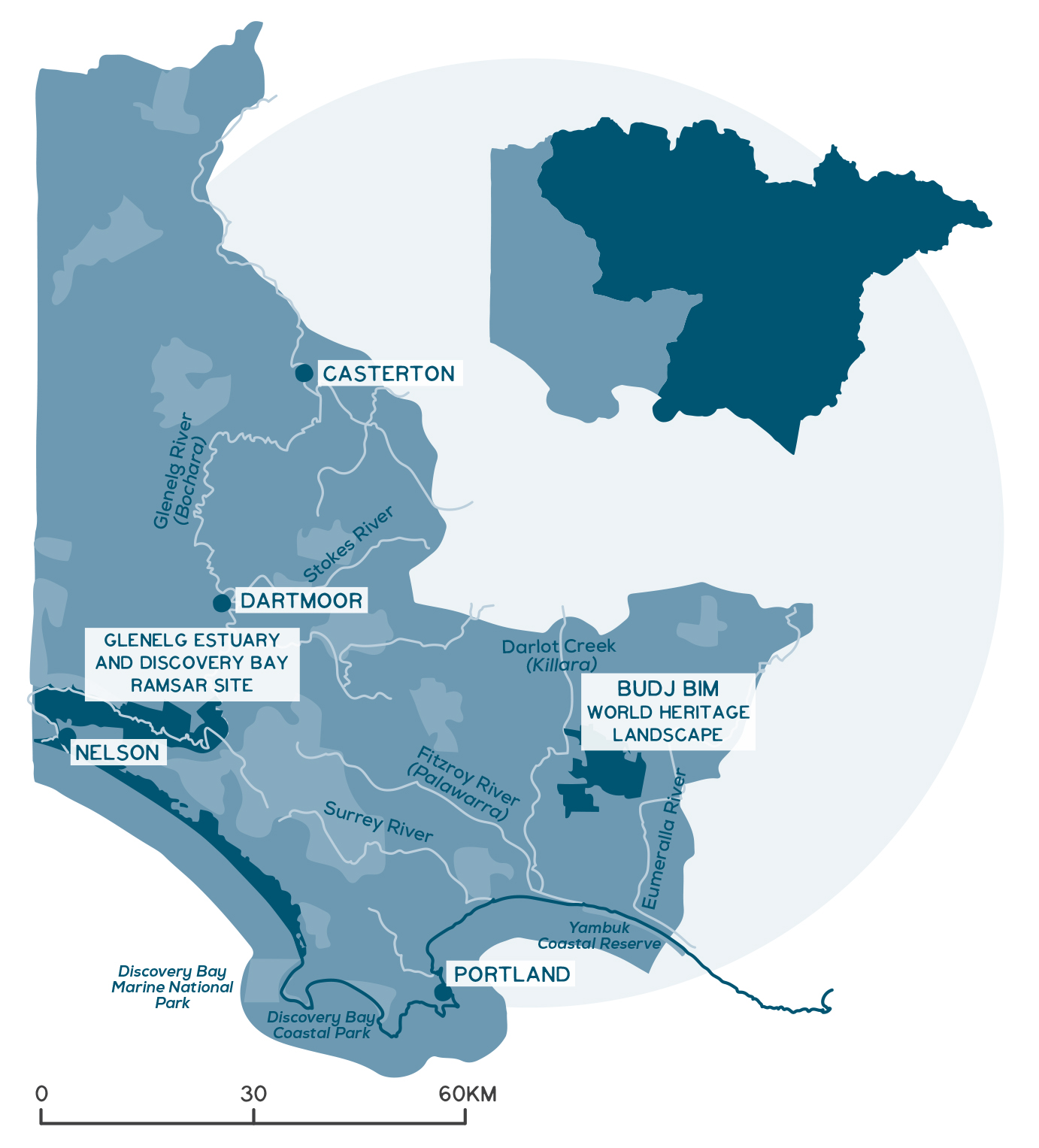
The Glenelg Plain includes large land areas reserved for conservation including the internationally significant UNESCO World Heritage listed Budj Bim Cultural Landscape and the Glenelg Estuary and Discovery Bay Ramsar site. The Glenelg River and its tributaries are key features of the landscape, winding from the Grampians to the coast.
The region has high rates of volunteering compared to the rest of Australia. Key Landcare networks include the South West Environmental Alliance and Upper Glenelg Landcare Consortium.
Local Government Authorities include Glenelg Shire, Moyne Shire and West Wimmera Shire.
A snapshot of the Glenelg Plain
- Key towns include Portland, Heywood and Casterton.
- High rates of community volunteering.
- Agriculture, fishing and forestry are the main industry employers.
- A declining, ageing rural population.
- The most agriculturally diverse local area in the Glenelg Hopkins region, with a mix of sheep, beef, dairy, forestry and cropping.
- Native vegetation covers 35% of the area.
- Large land areas reserved for conservation include the World Heritage listed Budj Bim Cultural Landscape and the Glenelg Estuary and Discovery Bay Ramsar site.
- Priority waterways include Glenelg River, Darlot Creek, Surrey River, Crawford River and Stokes River.
- Contains 30% of the Glenelg Hopkins region’s wetlands (more than 2,200).
- Coastal beaches and wetlands are important habitat for rare and threatened bird species.
- The Bonney Upwelling is a major marine asset supporting highly productive fisheries.
- Natural and culturally based tourism and recreation is important to this region.
- Key threats include loss of wetlands, native habitat and soil carbon due to land use change, declining river flows and water quality, climate change impacts on waterways, wetlands and coastal regions, and pest plants and animals.
Detailed overview
The Glenelg Plain is dominated by the Glenelg Plain bioregion, a landscape of long, low parallel limestone ridges, featuring extensive areas of damp sclerophyll forests of brown and desert stringybark. These forests provide an essential food resource for the nationally endangered south-eastern red-tailed black cockatoo. The Glenelg Plain contains other diverse habitats that support many threatened species. These including 54 recorded fauna species such as common bent-wing bat (critically endangered) and the Glenelg mussel (critically endangered), and 23 recorded flora species, including native orchids such as the colourful spider-orchid (endangered), Gorae leek-orchid (endangered) and Mellblom’s spider-orchid (endangered).
Among the forests are a mosaic of wetlands and damp heathlands occupying depressions in the landscape, with yellow and red gum woodlands on loamier soils. Vast wetland complexes once occurred across the landscape surrounding Strathdownie. Although many of these wetlands have been lost or severely degraded through drainage works, several nationally significant complexes remain.
This local area has around 30% of the region’s mapped wetlands, 99% of which are temporary freshwater lakes, swamps, marshes and meadows. The exceptions are a handful of more saline coastal wetlands. The shallow freshwater wetlands are important feeding and nesting habitat for a range of resident and migratory water birds, including brolgas. The lack of predatory fish in temporary wetlands means they are also important for frogs, including the threatened growling grass frog.
The Glenelg Plain is perhaps the most agriculturally diverse local area in the Glenelg Hopkins region. High rainfall in the south supports a prosperous forestry industry – soft and hardwood plantations – as well as dairy and horticulture. Moving north, beef and sheep production dominate with cropping increasingly integrated with these industries. Marine sediments below surface soils, create a freshwater aquifer running north and south. This enables improved summer growth for vegetation crops such as potatoes and grapes.
Seasonal wetlands are at high risk of loss in this area
Scarred trees are evidence of Aborignal history in the area
Gorea leek orchid – endangered
This local area features a large land area reserved for conservation of the region’s natural and cultural values, including the internationally significant World Heritage listed Budj Bim Cultural Landscape and the Glenelg Estuary and Discovery Bay Ramsar site – and a series of National Parks in the south – Lower Glenelg National Park, Cobboboonee National Park, Mt Richmond National Park and the Discovery Bay Coastal Park. These reserves capture a diverse range of natural landscapes, including forest, forest, swamps, woodlands and coastlines. State Forest reserves are also found throughout this local area.
These areas are key to nature-based tourism, recreational fishing and boating along key rivers and estuaries, hiking the Great South West Walk, camping in the many national parks and along the areas beaches, and visiting important cultural sites such as Budj Bim National Park. There is great opportunity for further diversification of tourism to capitalise on the area’s assets through eco-tourism, rail trails, food and wine trails, and the region’s Aboriginal history and culture. This area also has opportunities to make the most of its available natural renewable resources (such as wind, solar and water) to generate energy and use it locally.
By virtue of having relatively low levels of development and large remaining areas of remnant habitat, the Glenelg Plain is important for a range of values associated with waterways.
The Glenelg estuary has intact riparian vegetation in excellent condition and supports rare and threatened species such as the Glenelg spiny crayfish, threatened native fish and migratory bird species protected under international agreements such as sanderling. Water for the environment has helped maintain flow within the Glenelg system to maintain populations of native fish and other aquatic and riparian plant and animal species. Water for the environment has social, cultural and economic benefits, including those for recreational anglers, landholders and Traditional Owners who live along and enjoy the river system.
Bochara/Bugara/Pawur – The Glenelg River
Known as Bochara in Dhauwurd Wurrung language, Bugara in Wergaia-Jadawadjali languages and Pawur in Bunganditj languages, the Glenelg River is a significant feature within the cultural landscape of south-west Victoria.
The river features in creation stories for the region and is a traditional boundary between the Gunditjmara, Boandik and Jadawadjali people. There are many cultural sites along the river system showing evidence of the area’s occupation and use by Aboriginal people.
Bochara/Bugara/Pawur is still a significant place for Traditional Owners, who have inhabited the area for thousands of years.

Other priority waterways include:
- Killara or Darlot Creek (including Lake Condah), the lower Fitzroy River (Palawarra) and its estuary, which form part of the Budj Bim World Heritage Cultural Landscape.
- The Surry River and its estuary, which support seagrass beds in excellent condition and a range of dependent recreational fishing and ecological values.
- The Crawford River, which contains high environmental and social values and supports a number of threatened fauna species, including the Gorae leek orchid, Glenelg freshwater mussel, brolga, brown quail, river blackfish and variegated pygmy perch.
- The Stokes River, which contains significant riparian vegetation communities and fauna including red-tailed black cockatoo, Glenelg spiny crayfish, river blackfish and variegated pygmy perch.
Groundwater close to the surface is an important source of water for many wetlands and is a known contributor to the hydrology of the Glenelg River estuary and the freshwater wetlands of the coastal zone, e.g. Malseed Lake, Lake Moneboeng, Long Swamp, Bridgewater Lakes. Groundwater is also important for economic development. Within the Glenelg region it is used for irrigation and other agribusiness, urban water supply and regional industries, particularly manufacturing within the Portland area.
The region’s dramatic coastline, with its towering cliffs and extensive dune systems, has been carved out by changing sea levels, volcanic activity, and wind and water erosion. Coastal land extends 5 km in from the highwater mark and the boundary between state and commonwealth marine waters is 5.6 km out from the highwater mark. The high biodiversity values east of Discovery Bay and the Glenelg River estuary are internationally recognised as a Ramsar site and an Australian Key Biodiversity Area (KBA). It contains coastal scrub and small patches of herb-rich eucalypt woodland. Its beaches and wetlands provide important habitat for Australasian bitterns, hooded plovers, orange-bellied parrots, rufous bristle birds and striated fieldwrens. The beaches between Lake Yambuk and the Fitzroy River are also a KBA, with the highest breeding density of hooded plovers in Victoria.
The marine environment is within the Otway marine bioregion, with powerful waves, cold, nutrient-rich water, kelp dominated rocky reefs and a seafloor that drops away steeply offshore. Its high productivity and biodiversity are driven by the Bonney Upwelling that forms from spring to autumn. The algal blooms this creates are the base of a rich food chain including fish, southern rock lobster, abalone, seabirds, penguins, fur seals and blue whales. The Bonney Upwelling is recognised as a major marine asset and supports highly productive fisheries. Portland reefs are the most productive abalone habitat in Victoria, as well as the largest rock lobster port in Victoria. The Port of Portland is also the hub of wild catch fishing in the region, providing permanent berthing facilities for about 50 commercial vessels and contributing more than 40% of Victoria’s catch value.
Port of Portland
Fur seals are a common sight along the coastline
Discovery Bay
Challenges and threats
The expansion of land under cropping has the potential to increase soil disturbance and bare ground leading to loss of carbon from soils traditionally under pasture. This also leads to increased nutrient runoff into waterways. Risk of soil and carbon loss can be reduced through cropping practices such as minimum or no-tillage, stubble retention and cover cropping. Increasing intensification of farm production also accelerates the process of soil acidification which is, and will remain, a threat to farm productivity and soil health within this area. The increase of agricultural irrigation within this area also needs to be considered in light of environmental impacts and sustainable development.
Maintaining groundcover is an important practice in the Glenelg Plain, where sandy and loamy surface soils become susceptible to erosion when exposed. Perhaps more than other land uses, plantation forestry soils can become acidic and low in available nutrient. Whether returned to pasture or forest, soil testing and ameliorative actions are critical to restore productivity.
Key threats to wetland values include land use change and increases in softwood plantation forestry closer to the border with South Australia. Other threats include widespread drainage, pest plants and animals, loss of buffering vegetation and habitat fragmentation. Hydrological restoration, revegetation works and supporting landholders with change management practices will be critical to improve wetland resilience under climate change.
Changes to water availability, including through climate change, have the potential to impact the many shallow freshwater wetlands in this area that support an enormous diversity of aquatic plants, water birds, frogs, invertebrates and contribute much to the amenity and character of the local area.
The Glenelg River requires special consideration as the only waterway that receives managed water in the region. The long-term water resource availability in the Glenelg has declined by around 6% against benchmarked flows set in the Western Region Sustainability Water Strategy. Water quality trends across the region also indicate increasing nitrogen, phosphorous and turbidity at most localities.
Estuaries and their associated wetland complexes are particularly susceptible to climate change impacts, including increased storm surge coupled with reduced inflows that are likely to affect the estuaries, with changed natural opening/closing regimes. In addition, riverine flooding across the towns of Casterton, Heywood, Portland and Narrawong and rural areas result in damage to both the community and natural environment. More frequent and intense downpours under climate change is expected to increase the risks of flooding.
Dairying is one of the key industries in the area
The endangered red-tailed black cockatoo
Photo: Michael Waters
Looking back towards Cape Bridgewater
Native vegetation makes up 35% of land cover in this area and has declined by 12% since 1990. Declines were particularly severe in the early 1990s, resulting in a 64% loss in native grassland extent, 63% loss in native vegetation cover in seasonal wetlands, and a 35% decline in heathland cover. Habitat loss through clearing and stock grazing continues to be a significant threat, particularly for seasonal herbaceous wetlands and large hollow-forming trees that provide habitat to native birds and mammals. Climate change has been linked to increased tree mortality across the area and is likely to drive significant increases in bushfire frequency and severity in the future.
The threat of predators, including foxes and cats, is likely to be compounded by bushfire. Pigs are an emerging risk to habitat (particularly wetland habitat) and cultural heritage values in this area. Common high-threat weeds include pine and coast wattle that invade forests and woodlands, developing dense canopies that inhibit the recruitment of other native plants.
One of the key challenges for management of the marine and coastal environment is climate change (sea level rise, changed weather patterns), which will squeeze coastal habitats, influence nutrient levels in estuaries and marine waters, and alter the duration and intensity of the Bonney Upwelling. Other threats include:
- Inappropriate artificial estuary openings causing fish kills.
- Built coastal structures such as breakwaters which alter patterns of sand deposition and erosion.
- Recreational use that disturbs nesting and feeding birds and affects on marine life.
- Elevated nutrients and sediments in estuaries, coastal wetlands and marine waters resulting from upper catchment processes and land management and pollution from wastewater outfalls.
Key socio-economic challenges that the community face include:
- A declining, ageing rural population outside of Portland.
- Low rates of post-secondary qualifications creating skills gaps.
- Distances to major cities and accessible transport routes affecting industry and tourism markets.
- Lack of business diversity affecting employment within key urban centres.
Community priorities and interests
The outcomes and priority management directions for the strategy are detailed under each theme, these set the strategic framework for the strategy.
Although all outcomes in the RCS are a priority across the region, each local area has different priorities for implementation based on the local values, threats, and community priorities. The strategy will be implemented via specific projects, or the core activities of a range of agencies, groups and local people involved in managing and conserving natural resources and biodiversity values.
Community priorities and interests that relate to the Glenelg Plain local area are outlined below. These priorities and interests have been raised by community and partners through the RCS engagement process. These are also reflected in the priority management directions under each theme and together they guide the implementation of the RCS within the different local areas.
Traditional Owner groups
Further detail on Traditional Owner groups in this local area can be found on their individual pages – click the names below:
* Barengi Gadjin Land Council
* Eastern Maar Aboriginal Corporation
* Gunditj Mirring Traditional Owners Aboriginal Corporation


