Groundwater is water found in the cracks and spaces in soil, sand and rock. It has accumulated from rainfall over long timeframes, and the quality of groundwater ranges from saline to very fresh. Groundwater supports a wide range of environmental and economic values across the Glenelg Hopkins region. Groundwater has a complex relationship with terrestrial, aquatic and marine ecosystems. These relationships are highly variable and often poorly understood.
Groundwater is a reliable resource for a range of consumptive purposes where it is economical to access, yields sufficient volumes of water and the quality of water is suitable for use. Agriculture, town water supply, food processing, geothermal energy and thermal spas are groundwater users within the region.
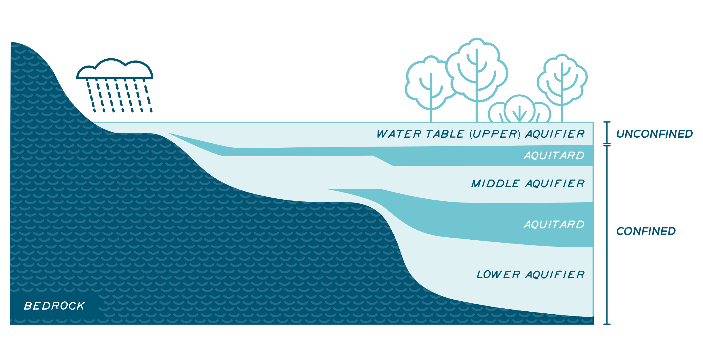
Groundwater resources are described as aquifers, water-bearing layers of permeable rock, rock fractures or unconsolidated materials1 (Figure 1). Access to groundwater varies across the region, mainly dependent on geology, water quality and water pressure. The depth from the surface to groundwater is a constraint to using the resource due to pumping costs.
Management of groundwater is challenging as physical processes are complex, hydrogeological terminology is highly technical, groundwater movements are not easy to observe, and recharge processes are also subject to long time lags.
Groundwater Dependent Ecosystems
Groundwater Dependent Ecosystems (GDEs)2 may be entirely or only occasionally dependent on groundwater.
When groundwater occurs close to the surface, it can support the hydrology of aquatic GDEs, including rivers, lakes, springs and soaks, which allows for the persistence of aquatic species for some period of the year. The Glenelg River is known to receive substantial groundwater inputs. Terrestrial GDEs are ecosystems typically featuring non-aquatic vegetation and ecological communities that rely on groundwater access to meet water demands for some or all the year.
Groundwater also supports a poorly understood group of subterranean organisms called stygofauna. The discharge of fresh groundwater into the marine environment supports a range of species and processes.
Assessment of current condition and trends
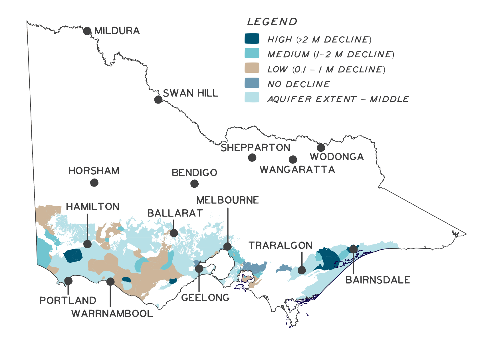
Groundwater resources are managed to allocate water for consumptive demands while protecting environmental values and maintaining aquifers’ integrity. Seasonal fluctuations in water level and the amount of time water remains in aquifers vary depending on a range of factors associated with each aquifer’s geology. Key factors include the aquifer’s total size and the amount of water it can hold, the degree of connectivity with the surface or other aquifers, the rate of horizontal flow through an aquifer, pressure within the aquifer, the rates of water use and aquifer recharge. The 2019 long-term water resource assessment for southern Victoria has identified a trend for declining water levels in upper and middle aquifers in the Glenelg Hopkins region (Figure 2). This trend is attributed to a range of factors, including changing seasonal rainfall patterns with more variable rainfall less able to infiltrate aquifers, declining annual rainfall volumes and changing land-use practices, such as drainage of recharge areas, changing vegetation to types that use more water and reduce infiltration, and increased urbanisation where the soil is covered with roads and buildings3.
Demand for groundwater resources is increasing across the region. Environmental and consumptive demand for groundwater is influenced by changing rainfall patterns and reduced surface water availability.
Major threats and drivers of change
Land use change
Changing vegetation to higher water use species reduces the water available to recharge aquifers. This was a significant issue during the rapid expansion of plantation forestry through the 1990s. Recent changes to forest policy may see renewed interest in plantation forestry developments in the region. The current driver for this threat is the southward expansion of broadacre cropping, which is replacing perennial pastures. Crop water demands reduce water availability compared to pasture, while practices used in higher rainfall areas, such as raised bed cropping, change the way that surplus water can infiltrate to recharge aquifers.
Surface and sub-surface drainage can also impact on recharge of aquifers. Retaining water in the landscape, including wetland systems, allows for the slow infiltration of water through the soil into aquifers and provides natural water filtering. Standing surface water can support the pressurisation of connected aquifers, and drainage can affect how water moves through an aquifer.
Drainage of aquifer discharge areas can have a range of impacts, including lowering water tables that can threaten GDEs, drying out peat, a growing fire management challenge, and exposing potential acidic sulphate soils. Changing from agricultural land use to urban land use occurs around growing communities such as Ballarat and Warrnambool. Urbanisation covers areas of porous soils with impervious surfaces such as roads, paths, carparks and buildings.
Land use conversion from dryland agriculture to irrigated agriculture is a key driver of groundwater use. Groundwater is a key water source for irrigation in parts of the region where groundwater is accessible and of suitable quality. Demand for groundwater is being managed through cap and trade approaches in several aquifers, with trade rules established to manage adverse impacts of further concentration of extraction on existing users, including the environment.
Climate change
Climate change is altering the amount, timing and distribution of rainfall, resulting in reduced recharge to aquifers. Other climate change impacts, such as forest fire regrowth and temperature changes can increase vegetation water demands, while reduced surface water availability increases the degree of groundwater dependence by GDEs. Reduced rainfall can also increase consumptive water demands for groundwater across various purposes, including urban supply, stock and domestic water demands and irrigation.
Energy development, mining and exploration
Conventional onshore oil and gas resources in the south-east of the region were extensively developed through the 1990s. The Petroleum Legislation Amendment Act 2020 has allowed the resumption of onshore conventional gas from July 2021. Conventional oil and gas exploration and extraction rely on drilling, often through aquifers, to access the resources for extraction. These processes create a range of risks to groundwater assets, including cross-contamination of aquifers with different water qualities. Dewatering, storage, and aquifer return (disposal) of water all carry risks to aquifer water quality. Bans on unconventional gas development, including hydraulic fracturing and coal seam gas are outlined in the Constitutional Amendment (Fracking Ban) Bill 2020.
Geothermal or ‘Hot Rocks’ energy is currently limited to direct heat transfer with hot groundwater reticulated through radiators in large buildings in Portland and thermal day spas. Commercial-scale geothermal electric energy generation developments are possible from the Dilwyn aquifer.
Forestry plantations are common across the southwest of the region
Cropping expansion in the region impacts on water availability and recharge
Centre pivot irrigation relies on groundwater access
Outcomes and priority management directions
Outcomes and priority management directions have been developed to show what success looks like for integrated catchment management (ICM) across the Glenelg Hopkins region. Below is the 20 year (long-term) outcome for groundwater. Within these are the proposed six-year outcomes and priority management directions to be achieved within the life of this strategy. The priority management directions are identified across the adaptation pathway stages of resilience, transition and transformation (see RCS approach for more information). Lead and key partners involved in delivery are also outlined.
By 2042, the hydrological requirements of priority Groundwater Dependent Ecosystems (GDE) are protected
| 6 year outcome, by 2027... | Resilience management priority | Transition management priority | Transformation management priority | Lead or coordinating responsibility | Delivery partners |
|---|---|---|---|---|---|
| Stakeholders are better informed about the hydrological needs of priority Groundwater Dependent Ecosystems (GDE) and the impacts of climate change and catchment activities, including landuse and the diversion of water, on groundwater. | Complete regional assessment to identify and prioritise GDEs and resource risk. Develop an engagement program focused on managers of land in areas where land use impacts on recharge, diversion or extraction of water. | Review existing groundwater monitoring network in priority locations and establish new infrastructure where data deficient. Pair groundwater observation and monitoring with monitoring of surface water and significant dependent ecological values. Improve understanding of recharge zones and develop programs to increase the amount of water retained in the catchment (e.g. Incentives for public benefit from water retained in wetlands). Improve understanding of the impacts of land use on recharge, groundwater quality and dependent GDEs. Improve understanding of terrestrial ecosystem interactions with groundwater. | Include needs of GDEs in planning for groundwater allocation. Improve understanding of stygofauna and risks to habitat values. Improve groundwater recharge through hydrological restoration of wetlands and rivers. | Glenelg Hopkins CMA | Southern Rural Water, research organisations, universities, industry groups |
| Changes in groundwater water balance are factored into resource allocation decisions and management. | Advocate for groundwater in the Sustainable Water Strategy (SWS) review. CMA response to Section 51 - take and use licence application referrals consider impact to values. Implementation of Sustainable Irrigation Program (SIP). | Managed aquifer recharge (local sites). Risk assessment of local areas of current and projected irrigation demand. | Advocate for the restoration of water tables in affected areas via the SWS review. | Glenelg Hopkins CMA | Southern Rural Water |
By 2042, changes in groundwater water balance are factored into resource allocation decisions and management
| 6 year outcome, by 2027... | Resilience management priority | Transition management priority | Transformation management priority | Lead or coordinating responsibility | Delivery partners |
|---|---|---|---|---|---|
| Any reviews of groundwater extraction and development controls include increased recognition of the needs of the regional environment, values associated with groundwater and future sustainability of the resource | Advocate for groundwater in the Sustainable Water Strategy (SWS) review. CMA response to Section 51 - take and use licence application referrals consider impact to values. Implementation of Sustainable Irrigation Program (SIP). | Managed aquifer recharge (local sites). Risk assessment of local areas of current and projected irrigation demand. | Advocate for the restoration of water tables in affected areas via the SWS review. | Glenelg Hopkins CMA, Southern Rural Water | DELWP |
Key strategies and plans that relate to the delivery of groundwater outcomes include:
- Water for Victoria
- Western Region Sustainable Water Strategy
- West Wimmera Groundwater Management Strategy
- Protecting Victoria’s Environment – Biodiversity 2037
- Australia’s Strategy for Nature 2019-2030
- Australian Government Threatened Species Strategy 2021-2031
- Marine and Coastal Policy
- South West Victoria Local Management Plans (Glenelg Groundwater Catchment Statement, Hopkins-Corangamite Groundwater Catchment Statement, Hopkins River Basin Local Management Plan, Portland Groundwater Catchment Statement, South West Limestone Groundwater Management Plan)
- Great South Coast Food and Fibre Strategy 2020
References
- Department of Environment, Land, Water and Planning (2019) Long-Term Water Resource Assessment for Southern Victoria: Overview Report (DRAFT), s.l.: The State of Victoria Department of Environment, Land, Water and Planning.
- Visualising Victoria’s Groundwater (2021) Visualising Victoria’s Groundwater. [Online] Available at: https://www.vvg.org.au/vvg_map.php?agreement=Agree+and+Continue# [Accessed January 2021].
- Department of Environment, Land, Water and Planning (2019) Long-Term Water Resource Assessment for Southern Victoria: Overview Report (DRAFT), s.l.: The State of Victoria Department of Environment, Land, Water and Planning.


