With about 81% of the Glenelg Hopkins catchment used for primary production, healthy soils are critical to the region’s future prosperity and are fundamental to increased production of agricultural commodities and the sustainability of farming communities. As an agricultural landscape, most soils are managed by farmers, making them best placed to make, and implement, decisions to improve and protect soil.
Soil takes a long time to form1 and is a mix of sand, silt, clay and organic matter. Soil health can be defined as2:
“the condition of the soil in relation to its inherent or potential capability, to sustain biological productivity, maintain environmental quality, and promote plant and animal health “Soil Health for Victoria’s Agriculture, 2007
Healthy soils provide a range of ecosystem services that “maintain fertility by cycling nutrients and decomposing wastes, provide a habitat for a vast array of organisms and support terrestrial ecosystems that are responsible for providing clean air and water as well as a regulated climate”3. In addition, terrestrial habitats, supported by healthy soil, play an important role in maintaining microclimates – a key factor affecting the distribution of many species and lowering water tables4.
Specific processes that have been identified for priority attention at a regional level include:
- Soil acidification.
- Inadequate groundcover in erosion susceptible areas.
- Sodic soils that are prone to water erosion and are highly erosive.
- Movement of sediment and nutrient into rivers, lakes and estuaries.
- Soil contaminants, such as salt and acids.
- Soil structure decline.
- Improving knowledge and understanding of the distribution of coastal acid sulphate soils.
Soils
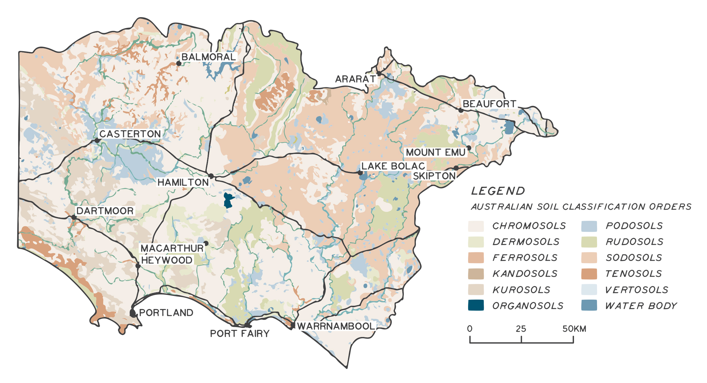
The catchment contains 49 major soil types that vary in texture, structure, fertility and drainage characteristics. These can be grouped into 12 Australian Soil Classification Orders (Figure 1). Spatial distribution of regional soils is complex. This large variation is due to different ages, geology of the parent material and weathering processes active over their period of formation. The resulting soils vary in suitability and capability for agricultural production and susceptibility to processes that would degrade soil health. More than 80% of the region’s soils have chemical or physical limitations affecting agricultural management for sustainable productivity and maximum recharge control.5 Limitations include nutrient deficiency, acidic topsoils, shallow soil profiles and poor soil structure.
Assessment of current condition and trends
Assessment of trends in soil condition is problematic. There is no standardised approach to soil monitoring at a national scale, and there are no benchmarks of soil health for different soil types at a statewide level6.
“Unless soil condition can be related to a benchmark value, soil health cannot be properly evaluated. While the development of a soil health index has been proposed, its components have not been identified”
VCMC Catchment Condition Report, 2012
This issue has been identified as a focus area in the National Soil Strategy, with specific progress measures targeted at addressing this issue.
In order to better understand the condition of farmland soils in the Glenelg Hopkins region, 100 soil monitoring sites have been established across the region through the Australian Government’s Regional Land Partnerships Program. Soil testing has enabled a high-level picture of soil condition to be formed. Of the soils tested, 89% were found to be acidic (pH<5.5). Soil carbon levels ranged from 0.5% to 10.6% and were closely associated with rainfall and highest under permanent pasture. Sites will be retested in 2023, allowing changes in soil chemical condition to be measured and identified.
Groundcover is commonly used as an indicator of soil health at a regional level. Bare soil can be used as a proxy for erosion risk because exposed soil is more likely to suffer from wind or water erosion7. The recommended amount of groundcover to maintain an acceptable risk of erosion in eastern Australia is 70%8.
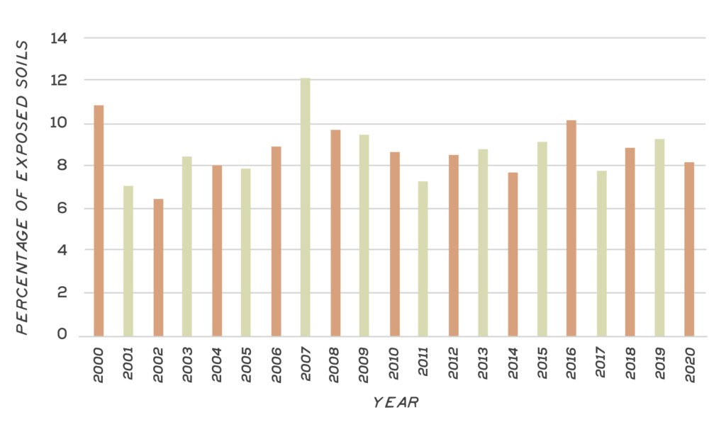
The Australian National University has assessed the extent of exposed soil nationally since 2000. The assessment uses MODIS satellite imagery that captures images of the earth’s surface every eight days over a 12-month period to analyse the percentage of ground not covered by living or dead plant material. The maximum percentage of exposed soil across the Glenelg Hopkins region to December 2019 is shown in Figure 2. The percentage area of exposed soil across the Glenelg Hopkins region has varied marginally on an annualised basis over the past 20 years, with a range of 6%-12%.
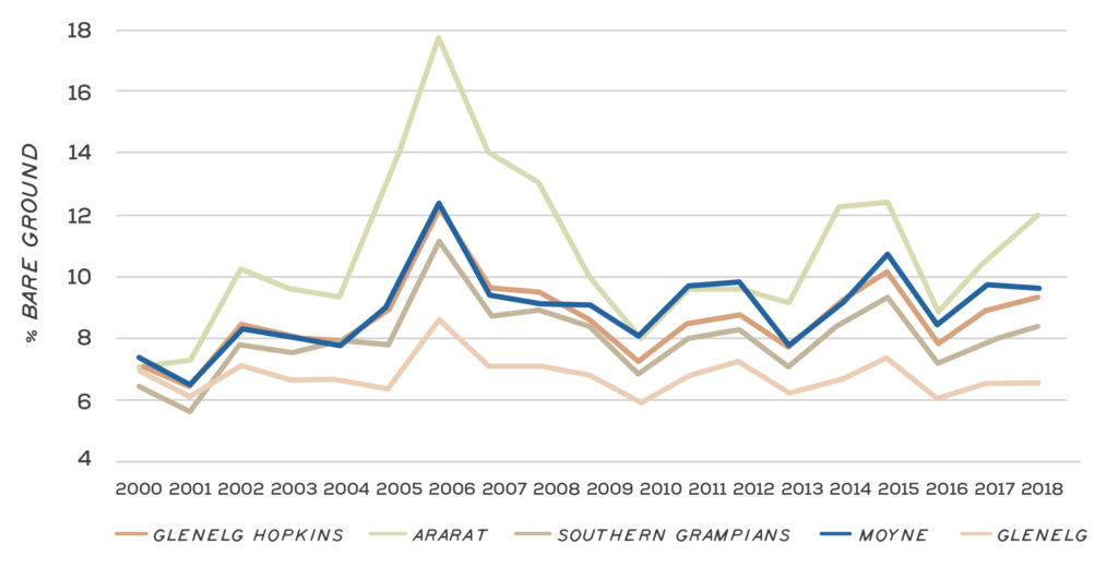
Figure 3 shows the annual percentage of bare ground for the five largest Local Government Areas within the Glenelg Hopkins region between 2000 and 2018. The consistent higher percentage of bare ground observed in the Ararat Local Government Area (LGA) could be attributed to a combination of factors including relatively lower rainfall and warmer summers experienced in this area, and the LGA being predominantly a cropping area. Bare ground targets for cropping areas are typically 50%. While there are increased risks of erosion in areas with more bare ground, the percentage area of exposed soil across all five LGAs is less than 20%, and typically less than 12% on an annualised basis since 2000.
Major threats and drivers of change
Climate change
Climate has a direct impact on soil health and has its most severe impacts in extremes of dryness leading to wind erosion and, in extremes of wetness leading to sheet, rill and gully erosion. Soil erosion is likely to be exacerbated by the projected increases in intense rainfall events where those rains fall on dry, denuded soils9.
In addition to an increase in hot days, climate models indicate a related increase in extreme events such as heat waves, droughts and wildfires10. Heat-related extremes and wildfire can seriously impact soils, as well as water quality, because dry, burnt soils are more prone to erosion. Severe wildfire removes organic matter, resulting in soil structure deterioration and considerable nutrient loss. Associated with this loss is a significant reduction in the quantity and composition of microbes and invertebrates. These impacts may be ameliorated through the early restoration of vegetative cover11.
Soil acidification
Soil acidification is a natural process that occurs very gradually in undisturbed ecosystems. It can be accelerated by vegetation clearing and agriculture12. The main impacts of soil acidification include: a reduction in productivity and plant growth, reduced soil biological activity and availability of nutrients, loss of vegetation, and increase risks of erosion and soil structure decline; which can have a significant economic impact on landholders13.
Naturally acidic and acidifying soils typically occur in areas where rainfall is in excess of 500 mm/year; with the most strongly acidic soils occurring in permanent pasture areas14. Some agricultural practices can accelerate the rate of acidification. A key production system challenge is to either neutralise the additional acid or slow the acidification rate.
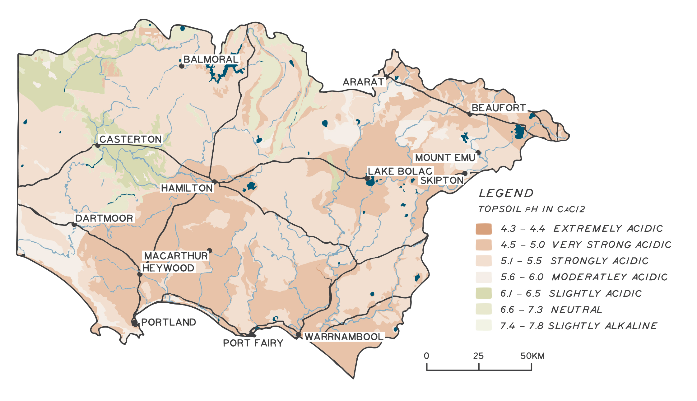
Most of the Glenelg Hopkins region has a high inherent susceptibility to soil acidification, with an estimated 74% of agricultural soils in the region strongly acidic15. Strongly acidic soils can be defined as soils with a pH less than 4.516. There is a risk of further soil acidification in parts of the region under agriculture, particularly in areas receiving more than 500 mm of annual rainfall. The Glenelg Hopkins region has been identified as one of the Victorian NRM regions most at risk of soil acidification17. Methods for managing surface soil pH include application of lime and/or dolomite and testing of soil pH. Improved matching of fertiliser applications to crop requirements through soil nutrient testing can also assist in slowing soil acidification. A map of regional top soil acidity is shown in Figure 4.
Wind erosion
Soil erosion is a natural process that is influenced by a range of factors including soil type and slope. The rate of erosion can be accelerated by factors such as production systems (e.g. burning of crop residues) and availability of ground cover. A reduction in the vegetation cover of soils is the primary trigger for soil erosion18.
Erosion and soil structure decline are closely linked because soil structure degradation increases the potential for removal of top soil from wind and water erosion. This, in turn, impacts soil health, as organic matter and nutrients are lost, and habitat is reduced for species such as fungi and earthworms, which help stabilise soil structure19.
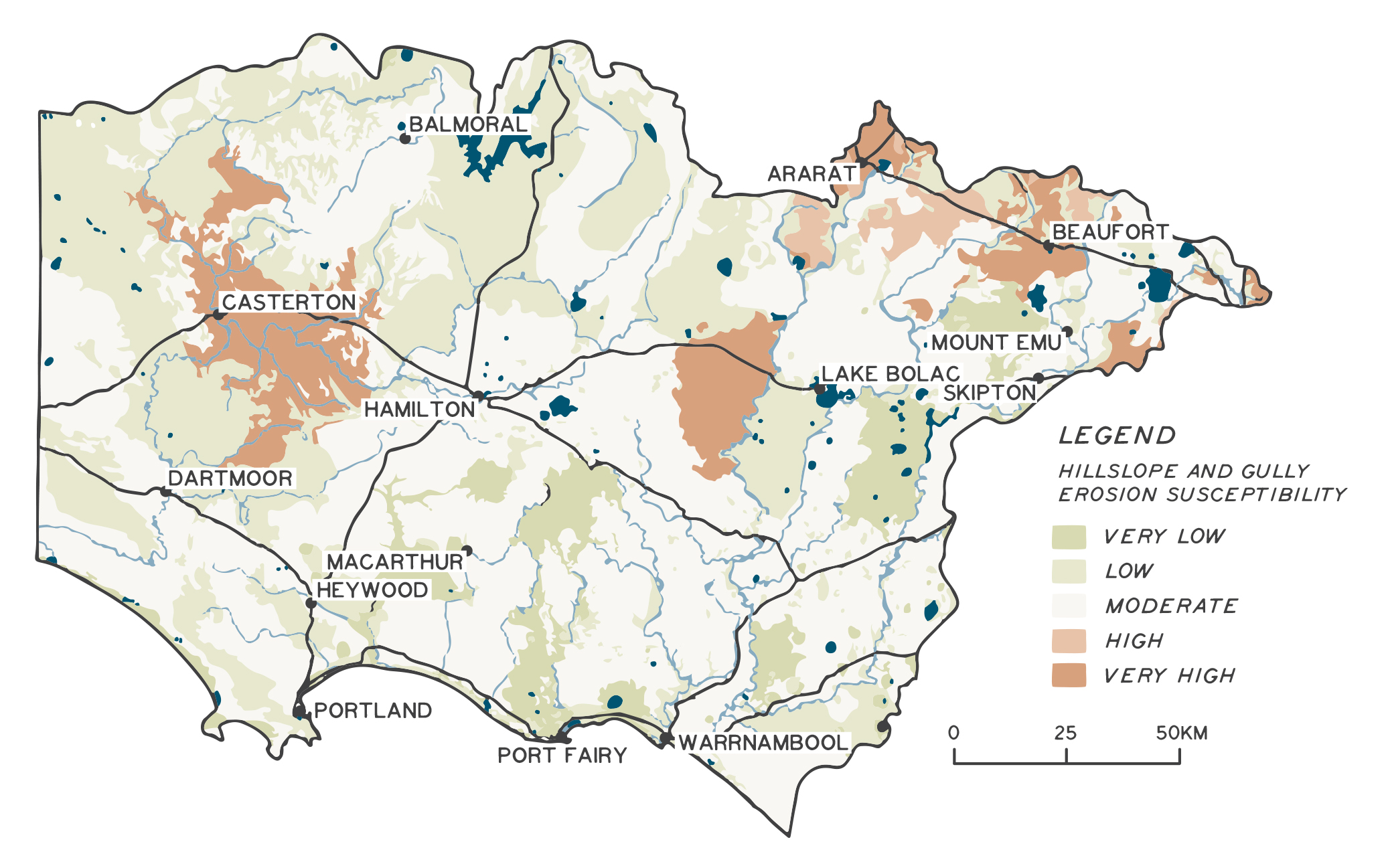
Soil landscapes most susceptible to wind and water erosion have been modelled at a statewide level in 201120. About 16% of the catchment has been estimated as having a high to very high inherent susceptibility to wind erosion21. Soils in the west of the catchment in the Glenelg Plain and Dundas Tablelands areas have very high inherent susceptibility to wind erosion. Soils in the Discovery Bay and the Nelson Plain area near Portland are also particularly prone to wind erosion.
Water erosion
Areas of the catchment that have been identified as being at particularly high risk of water erosion include the Ararat Hills, Dundas Tablelands, areas around Beaufort and to the west of Lake Bolac (Figure 5). About 18% of the catchment has been estimated as having a high to very high inherent susceptibility to sheet and rill erosion and around 12% for gully and tunnel erosion22.
The long-term effects of continued erosion can be seen in sediment deposits in the region’s river systems, particularly in the Glenelg Basin. Extensive sheet, tunnel, gully and stream bank erosion has led to large volumes of sand being trapped in the Glenelg River and its tributaries23. Substantial remediation works have been undertaken over the past decade to address this threat, including the reinstatement of logs to ‘plug’ sand movement through a combination of immobilisation using logs and fencing to promote in-stream vegetation.
Water erosion from storm surges also remains a key threat to regional coastal assets, such as sensitive dune environments and public/private infrastructure. For example, storm surges can alter the conditions on which vegetation types depend on and remove stretches of beach24. Dutton Way in Portland is an example of a coastal area that has been subject to long-term erosion; and a 4.5 km informal sea wall has been built to protect road and residential properties25. Other coastal assets in areas such as Port Fairy are also under threat from storm surges and water erosion.
Loss of soil organic carbon
Soil organic carbon (also soil organic matter) refers to all non-living material in and on the soil that is derived from living organisms. Soil organic carbon is a key indicator of soil health26. Soil organic matter is a vital component of healthy soils and has many benefits in terms of soil structure, water-holding ability, support of soil organisms and release of nutrients. Soil cultivation can result in loss of organic matter and carbon, although minimum tillage practices can help reduce this through less soil disturbance27. Other techniques that can help improve soil organic carbon include diverse rotations, cover crops, organic applications and management of fertiliser inputs28,29. Farm practices, such as burning30, that encourage oxidation of carbon may reduce soil organic matter.
A study of 615 sites on farms across western and south-eastern Victoria, identified rainfall as the most reliable link to organic carbon levels in soil, with higher soil organic carbon levels in high rainfall areas31 (Figure 6). Soil carbon levels are also generally higher under pasture, compared with cropping, with some variation between grazing systems32. Bushfires can impact carbon stocks through reduction in soil organic matter, and soil organic carbon is “likely to be impacted by climate change with increased periods of drought and fire risk”33.
Cover crop
Biochar demonstration site
Salt crust from saline groundwater discharge
Dryland salinity
Dryland salinity is generally categorised as primary or secondary. Primary salinity is a natural feature of the landscape and may have existed for thousands of years prior to European settlement in many parts of Victoria. Secondary salinity refers to salinity that has occurred as a “direct consequence of post-European settlement activity” (e.g. land use change, land clearing), which has unbalanced the natural water table levels, causing a rise in saline water tables34.
Dryland salinity has been estimated to affect more than 27,000 ha of the catchment. The region has the second largest area of land affected by dryland salinity in Victoria35.
The 2013 Victorian Dryland Salinity Update outlines the management approaches and understanding of dryland salinity in Victoria. It highlights advancements in the understanding of dryland salinity at a statewide level, including:
- The identification of salinity provinces across Victoria
- The potential risk caused by salinity appears to be cyclic, following climate variations
- Dryland salinity can be the result of anthropogenic sources, a natural feature of the landscape, or the result of a combination of both36.
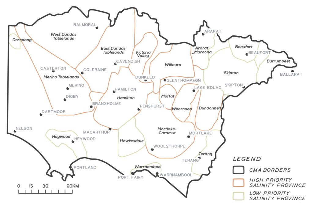
Although the spread of dryland salinity is considered to have slowed or receded in many areas of Victoria due to the recent dry period, the threat is likely to increase if there is a return to wetter conditions37, as more water is available to drive salinity processes38. High-priority salinity provinces that have been identified within the Glenelg Hopkins region are shown in Figure 6.
Other regionally significant threats to soil
Decline of soil structure
Soil structure controls the movement of water and air through the soil and therefore affects the supply of oxygen and the removal of carbon dioxide resulting from the respiration of roots and soil organisms. Soil structure decline is influenced by soil type and slope39. It can be accelerated by animal and vehicle tracks and agricultural practices that reduce soil biological activity. This can damage soil structure and lead to compaction, decreased infiltration rates, increased runoff and increased erosion, as well as surface ponding and increased waterlogging. Surface crusts and compaction are the direct result of soil structure decline40. Sixty-six per cent of the region is considered highly susceptible to soil structure decline41.
Waterlogging
Historically, waterlogging is widespread on sloping and rolling country, such as on the Dundas Tableland and the basaltic plains42. In many areas it is a natural condition, but in other parts it has been exacerbated by clearing of native vegetation. Grazing on waterlogged soils can lead to pugging. Traditionally, waterlogging has been a high priority threat to soil health in the region. In recent decades, lower annual rainfall and longer periods between rainfall events has reduced the incidence of waterlogging at a catchment level.
Coastal acid sulphate soils
Acid sulphate soils are soils or sediments that contain (or once contained) high levels of reduced inorganic sulphur. When exposed to oxygen, the soils or sediments undergo a chemical reaction that produces acid.
Disturbance of acid sulphate soils can result in fish deaths or other negative effects on waterways. The processes through which acid sulphate soils affect waterways are not all well understood and their location and level of risk is often uncertain. Acid sulphate soils occur predominantly in the coastal area but are also found inland in areas such as the Dundas Tablelands (associated with permanently flowing springs) and in waterways affected by dryland salinity.
Land management practices to improve soil condition
The land management practices that farmers choose can have a major impact on soil condition. Improved knowledge and understanding of regional and local soil types, and adoption of farming practices more suited to local landforms and climatic conditions, has seen a large-scale reduction in soil degradation and erosion events.
An Australian Government funded report into land management practices, soil condition and ecosystem services found that “… many of the current and emerging approaches to managing soils in Australia appear to be effective, or have the potential to be effective, at addressing the major concerns of declining soil carbon content, increasing pH in some areas, and wind and water erosion“43. Some conclusions from this report are summarised in the table below. Improved management practices can help slow rates of acidification and soil carbon decline, reduce soil loss through wind and water erosion, and improve productivity44.
| Land management practice | Type of agriculture | Increases soil carbon | Reduces risk of wind erosion | Reduces risk of water erosion | Reduces risk of soil acidification (low pH) |
|---|---|---|---|---|---|
| No cultivation/tillage apart from actual sowing | Broadacre cropping | Indirectly benefits | Directly benefits | Directly benefits | Indirectly benefits |
| Stubble left intact | Broadacre cropping | Directly benefits | Directly benefits | Directly benefits | |
| Reduce fallow | Broadacre cropping | Directly benefits | Directly benefits | Directly benefits | |
| Soil pH testing | Broadacre cropping, horticulture, dairying, grazing (beef cattle/sheep) | Indirectly benefits | Indirectly benefits | Indirectly benefits | Directly benefits |
| Lime or dolomite applied to reduce soil acidity | Broadacre cropping, horticulture, dairying, grazing (beef cattle/sheep) | Indirectly benefits | Indirectly benefits | Indirectly benefits | Directly benefits |
| Monitoring of ground cover | Dairying, grazing (beef cattle/sheep) | Directly benefits | Directly benefits | Directly benefits | |
| Use of ground cover management targets | Dairying, grazing (beef cattle/sheep) | Directly benefits | Directly benefits | Directly benefits | |
| Pasture phase in crop rotations | Broadacre cropping | Directly benefits | Indirectly benefits | Indirectly benefits | |
| Increasing perennial pastures | Dairying, grazing (beef cattle/sheep) | Directly benefits | Directly benefits | Directly benefits | |
| Soil nutrient testing | Broadacre cropping, horticulture, dairying, grazing (beef cattle/sheep) | Indirectly benefits | Indirectly benefits | Indirectly benefits | Directly benefits |
Outcomes and priority management directions
Outcomes and priority management directions have been developed to show what success looks like for integrated catchment management (ICM) across the Glenelg Hopkins region. Below is the 20 year (long-term) outcome for soil health. Within these are the proposed six-year outcomes and priority management directions to be achieved within the life of this strategy. The priority management directions are identified across the adaptation pathway stages of resilience, transition and transformation (see RCS approach for more information). Lead and key partners involved in delivery are also outlined.
By 2042, there is an increase in area of land managed for improved soil health
| 6 year outcome, by 2027... | Resilience management priority | Transition management priority | Transformation management priority | Lead or coordinating responsibility | Delivery partners |
|---|---|---|---|---|---|
| 800 land managers have an awareness of and/or adoption of land management practices that improve and protect the condition of soil. | Conduct survey to establish baseline information for awareness and adoption of land management practices that improve and protect the condition of soil. Deliver workshops that provide opportunity for land owners to increase their awareness and adoption of land management practices that improve and protect the condition of soil. Support farm businesses to develop nutrient management plans. | Deliver programs to increase the uptake of Integrated Pest Management and Weed Management on farms. Establish farm demonstration trials to test innovative farm practices to improve and protect soil. | Land managers are supported to adopt Integrated Pest Management and Integrated Weed Management strategies. Land managers are supported to adopt farm practices to improve and protect soils. | Glenelg Hopkins CMA | Agriculture Victoria, agricultural industry groups, Wannon Water, Meat and Livestock Australia |
| 400 land managers have knowledge and awareness of soil health and the associated beneficial ecosystem services. | Conduct survey to establish baseline information around knolwedge and awareness of soil health and the associated beneficial ecosystem services. Support land managers to increase capacity to monitor indicators of soil condition. Develop soil monitoring sites and identify trends in soil condition. | Soil health indicators developed. Farmers are supported in monitoring indicators of soil health and managing soils to capability. | Soil loss risk areas are identified. Land managers are supported to increase ecosystem literacy and understanding of role of ecosystem function and production and public benefit of ecosystem services. | Glenelg Hopkins CMA | Agriculture Victoria, agricultural industry groups, Meat and Livestock Australia, Wannon Water |
| Annual mean percentage groundcover is at, or above, 85% (less than 15% of ground exposed). | Extension programs focusing on groundcover maintenance. | Land managers are supported to use new technology to monitor ground cover and manage animal grazing to prevent over-grazing (bare ground). Support initiatives towards increasing diversity of pastures - both native and introduced species suitable for forage. | Land managers are trialling methods to increase plant diversity in pastures Land managers are supported to trial crops sown with more than one species. | Glenelg Hopkins CMA | DELWP, Agriculture Victoria, Local Government, Landcare groups, agricultural industry groups |
| 60 land managers are managing for improved soil carbon levels. | Opportunities for increasing soil carbon are promoted across the region. System for benchmarking and monitoring of soil carbon levels are known (Clean Energy Regulator). | The beneficial relationship between ecological sustainability and productivity is communicated to land managers. Build knowledge and capacity of land managers to participate in carbon markets. | Land managers are supported to trial practices known to increase soil carbon levels including: reducing soil disturbance (no-till cropping, pugging prevention), pasture phase in their crop rotation, addition of biomass (compost, stubble retention), multispecies cover and forage crops. | Glenelg Hopkins CMA | DELWP, Agriculture Victoria, Local Government, Landcare groups, agricultural industry groups |
Key strategies and plans that relate to the delivery of soil health outcomes include:
- National Soil Strategy
- 2030 Dairy Sustainability Goals and Targets
- The Australian Beef Sustainability Framework
- National Farmers Federation – 2030 Roadmap
- Drought Resilience Funding Plan for 2020 to 2024
- Southern Grampians Shire Council Plan 2017-2021
- Protecting Victoria’s Environment – Biodiversity 2037
- Australia’s Strategy for Nature 2019-2030
- Australia’s Native Vegetation Framework
- Glenelg Hopkins Climate Change Strategy

