Greener, vibrant, connected
Vision: To ensure health and sustainability for Ballarat’s landscapes and community
Ballarat is Victoria’s largest inland city with a population of 110,000, of which about 27,000 living in the Glenelg Hopkins region. The city derives its name for the Wadawurrung language, meaning ‘resting place’. Wadawurrung Traditional Owners Aboriginal Corporation is the Registered Aboriginal Party for this local area.
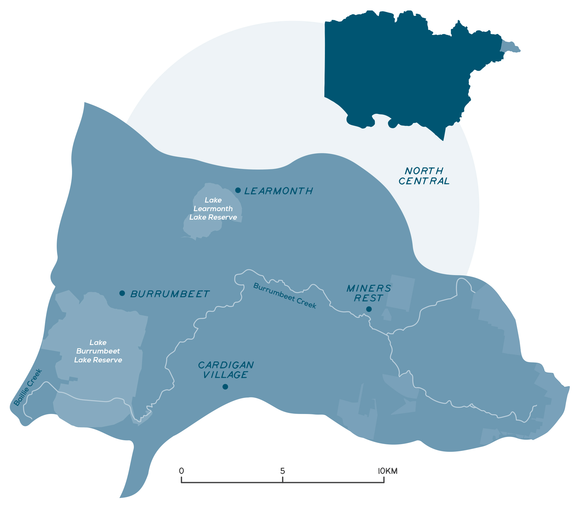
Ballarat sits on the confluence of three CMA regions – Glenelg Hopkins, Corangamite and North Central CMA, with about one-third of the city falling within the Glenelg Hopkins region.
Health care and social assistance are the main industry employers, followed by retail trade and education and training.
Key Landcare networks include the Ballarat Environment Network and the Upper Mount Emu Creek Landcare Network.
City of Ballarat is the Local Government Authority for this area.
A snapshot of the City of Ballarat
- Ballarat is Victoria’s largest inland city and is growing rapidly.
- About one-third of the city falls within the Glenelg Hopkins region.
- Health care and social assistance are the main industry employers.
- About 90% of residents in the City of Ballarat live in urban areas.
- The identity of Ballarat is linked to the combination of urban and rural areas which make this place special.
- The rural townships of Burrumbeet, Learmonth and Cardigan Village are spread across the agricultural landscape to the west of city centre.
- Mining, agriculture and historical clearing of native vegetation has had a significant impact on the condition of land.
- About 38,000 ha of land in the City of Ballarat forms part of a farm holding and is used for agricultural purposes; a large portion of this is in Glenelg Hopkins region.
- Agricultural activities include broadacre sheep and beef grazing, poultry and horticulture.
- Although a small area, it is rich in wetlands with around 150 mapped.
- Key waterways and wetlands include Burrumbeet Creek, Lake Burrumbeet and Lake Learmonth.
- Urban growth, integrated water management, agricultural diversification, flood management and biodiversity conservation are key challenges.
Lake Burrumbeet
Photo: Andrew Thomas
Detailed overview
The City of Ballarat is the smallest local area in the Glenelg Hopkins Catchment and is defined by a diversity of people, services and industries.
As a regional centre, Ballarat’s service catchment extends beyond its city borders and encompasses major retail, health and education facilities. People from surrounding rural areas, particularly to the west, are attracted to Ballarat for employment and education purposes as well as its significant history and lifestyle. Ballarat attracts many people from the Melbourne metropolitan area, including families seeking more affordable housing with good access to employment opportunities and better lifestyle choices. People also come to Ballarat as visitors – it is a key tourism location in the distinctive Central Victorian Goldfields region.
About 90% of the City of Ballarat residents live in urban areas. These areas are expected to experience the greatest growth and change in population over the coming decades. Ballarat’s identity is intrinsically linked to the concept that it is the combination of urban and rural areas. Those living in non-urban areas benefit from better services, more jobs and an increasingly prosperous CBD; urban residents benefit from vibrant and prosperous township and rural areas. The rural townships of Burrumbeet, Learmonth and Cardigan Village are spread across the agricultural landscape to the west of the urban centre.
Mining, agriculture and historical clearing of native vegetation has had a significant impact on the condition of land throughout the municipality. About 38,000 ha of land in the City of Ballarat forms part of a farm holding and is used for agricultural purposes. The total area of the municipality is 74,000 ha or 740 km2. A large portion of this farming land is within the Glenelg Hopkins region. Agricultural activities are generally broadacre sheep and beef grazing, poultry, piggeries, potatoes and cereal cropping. Boutique crops grown in the municipality include Chinese vegetables, grapes, organic wheat and berries.
This local area is rich in wetlands, with around 150 mapped. Many of these are associated with Burrumbeet Creek – in Wadawurrung language Burrumbeet means muddy or dirty water. Lake Burrumbeet itself is the largest wetland in the area, followed by Lake Learmonth. These waterways and wetland assets have many cultural, environmental and recreational values that are subject to challenges including water security, inappropriate development, agricultural land use and increasing recreational use. Maintaining the health of these areas will become more important under a changing climate as refuges for the area’s remaining flora and fauna species, including threatened species such as the growling grass frog. They also have an important role across the area as natural drainage corridors, and as stream habitat and wildlife corridors.
Fourteen threatened species have been recorded in the Ballarat Local Area. Of these 11 are fauna species, including the golden sun moth (critically endangered), freckled duck (endangered) and grey-headed flying fox (vulnerable), and three are flora species – stiff groundsel (endangered), gragrant leek-orchid (endangered) and golden cowslips (vulnerable).
Lake Learmonth
Photo: Kate Healy
Growling Grass Frog
Photo: Craig Cleeland
Cardigan Village
Photo: City of Ballarat
Challenges and threats
Ballarat is among the top five growth areas in regional Victoria, with the population projected to increase by 60% to 160,000 by 2040. As the population grows, the demographics of the community and family structures are both forecast to change. Supporting housing developments is required to cater for these changes. As the population increases and ages, maximising the value extracted from existing and new infrastructure will be crucial. Urban growth also has impacts such as increased runoff, which increases the importance of best practice integrated water management.
Growth impacts surrounding rural and agricultural lands. There is significant risk that ad hoc land use change can compromise the viability and growth of agriculture within the area. Over the long term, issues of land and soil quality will become increasingly important as land is considered for either commercial or natural uses.
Meeting the increased irrigation demand of crops and accommodating new horticulture crops may be hindered by the availability of a secure irrigation water supply. Most of the irrigation water in the region is sourced from groundwater and the Bungaree Groundwater Management Area is already over-allocated and a declared water supply protection area. This situation is unlikely to ease in the future as Ballarat’s urban demand grows along with its population and climate change results in less rainfall and potentially less recharge to the aquifer. This will drive greater efficiency in irrigation techniques and the development of more drought-tolerant plants. Rising land values surrounding growing urban population centres, will also force a shift to high value, more intensive agricultural enterprises. Ballarat is well placed due to a history of manufacturing and innovation to contribute to food resilience by value adding to the food and fibre sector.
Ballarat is expanding at a rapid rate
Photo: City of Ballarat
Gorse is a prioirty weed found within the agricultural zone
Photo: Victorian Gorse Task Force
Burrumbeet Creek flooding agricultural land at Pund Hill Road, near Powells Road
Photo: City of Ballarat
Floodplain management is an ongoing challenge in Ballarat, as is the case for many built-up areas where original European settlements were close to wetlands and creeks to have ready access to water. As a consequence, some of the developed areas of Ballarat are flood-prone. The costs of flooding to community wellbeing and local economies are expected to increase as a consequence of change in the frequency and intensity of significant rainfall events under climate change. Management of these challenges requires continuous improvement in understanding flood risks and the application of risk reduction measures such as planning controls.
There is a need to prioritise ‘liveability’ that reflects the quality and amenity of the built and natural environments. This includes building community resilience to the impacts of climate change. Intermittent periods of drought, water restrictions and periods of extreme heat will put the street trees, open spaces, creeks and waterways under increasing stress. Better recognition, management and support for the natural environment are required to maintain the highly valued ‘Ballarat lifestyle’, including open spaces. As more people move into both established and new residential areas, the distribution and diversity of open space will be a significant challenge. The natural resources of the municipality have already been compromised by the historic land uses and subsequent urban development. There is a need to undertake an assessment of how best to manage remnant areas for biodiversity conservation. At present there is insufficient data and analysis on biodiversity within the area to guide decision making.
Community priorities and interests
The outcomes and priority management directions for the strategy are detailed under each theme, these set the strategic framework for the strategy.
Although all outcomes in the RCS are a priority across the region, each local area has different priorities for implementation based on the local values, threats, and community priorities. The strategy will be implemented via specific projects, or the core activities of a range of agencies, groups and local people involved in managing and conserving natural resources and biodiversity values.
Community priorities and interests that relate to the City of Ballarat local area are outlined below. These priorities and interests have been raised by community and partners through the RCS engagement process. These are also reflected in the priority management directions under each theme and together they guide the implementation of the RCS within the different local areas.


